IMAGES TAKEN NEAR TO
Amesbury Crescent, HOVE, BN3 5RD
Introduction
This page details the photographs taken nearby to Amesbury Crescent, BN3 5RD by members of the Geograph project.
The Geograph project started in 2005 with the aim of publishing, organising and preserving representative images for every square kilometre of Great Britain, Ireland and the Isle of Man.

There are currently over 7.5m images from over14,400 individuals and you can help contribute to the project by visiting https://www.geograph.org.uk
Image Map (Loading...)


Getting Data...Please wait
Leaflet Map data © OpenStreetMap
Images are licensed for reuse under creativecommons.org/licenses/by-sa/2.0
Notes
- Clicking on the map will re-center to the selected point.
- The higher the marker number, the further away the image location is from the centre of the postcode.
Image Listing (103 Images Found)
Images are licensed for reuse under creativecommons.org/licenses/by-sa/2.0
Image
Details
Distance
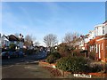
1
Amesbury Crescent
Beyond a crossroads the road continues down to the seafront as Berriedale Avenue.
Image: © Robin Webster
Taken: 23 Mar 2010
0.02 miles
2
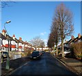
Park Avenue, Aldrington, Hove
A residential road that links New Church Road, the B2066, to Amesbury Crescent. Originally part of a field called West Laine according to Aldrington's 1840 tithe map by the 1880s it had become Wish Brick Field which supplied much of the building material for the developing suburb. As a consequence it was one of the last areas to be developed with the houses built in the mid 1930s.
Image: © Simon Carey
Taken: 14 Dec 2016
0.04 miles
3
Amesbury Crescent, Aldrington, Hove
A residential road that connects New Church Road, the B2066, to Coleman Avenue. Once a field called West Laine according to Aldrington's 1840 tithe map by the 1880s it was part of Wish Brick Field who supplied building materials for most of the suburb. Consequently, it was one of the last areas to be developed not completed until the mid 1930s.
Image: © Simon Carey
Taken: 14 Dec 2016
0.05 miles
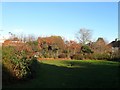
4
Davis Park, Hove
Small park off St Helier's Avenue in West Hove http://www.bhfederation.org.uk/accessible-city-guide/parks/hove/item/385-davis-park.html
Image: © Paul Gillett
Taken: 21 Apr 2012
0.05 miles
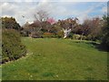
5
Davis Park, Aldrington, Hove
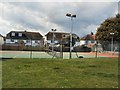
A small park which is tucked away out of sight to all but those who know of its existence. Entrance is via a gate on St Heliers Avenue then a path which runs between the houses on that road, then turns south passing the tennis courts of Image before arriving at this small rectangular green space. Originally part of a field called West Laine according to Aldrington's 1840 tithe map that had become Wish Brick Field by the 1880s who supplied much of the building materials for the suburb. The park was laid out in the 1930s.
Image: © Simon Carey
Taken: 14 Dec 2016
0.07 miles
6
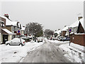
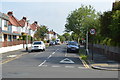
St Heliers Avenue
Residential street linking Portland Road to Amesbury Crescent that was developed during the mid 1930s.
Image: © Simon Carey
Taken: 2 Dec 2010
0.07 miles
7
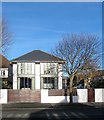
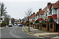
97, New Church Road, Aldrington, Hove
Located on the corner of Amesbury Crescent. The house dates from the 1930s but was refurbished and given a make over in 2007 by architect Martin Swanson.
Image: © Simon Carey
Taken: 14 Dec 2016
0.08 miles
8
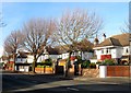
99-105, New Church Road, Aldrington, Hove
Located along with Image, out of shot to the right, between Amesbury Crescent and Park Avenue and developed in the early 1930s.
Image: © Simon Carey
Taken: 14 Dec 2016
0.08 miles