1
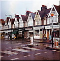
Westbourne Street, Aldrington, Hove
A residential street that runs from Westbourne gardens crosses Portland Road and continues northwards to the railway ending at the junction with Arthur Street. Built in the 1880s and named after a former stream that once ran to the sea and formed the old parish boundary between Hove and Aldrington.
Image: © Simon Carey
Taken: 11 Dec 2016
0.04 miles
2
The Westbourne, Portland Road, Aldrington, Hove
Completed in 1881 it was the first building to be erected in what later became Portland Road. Known initially as the Aldrington Hotel and later as just the Aldrington the pub acquired its current name sometime in the last decade located as it is on the corner of Westbourne Street. The road name is a reminder of an old ditch or stream that once formed the parish boundary between Hove and Aldrington. To the left is 1904 extension that was originally built as a billaird room.
Image: © Simon Carey
Taken: 11 Dec 2016
0.05 miles
3
Tony Magdi's, Portland Road
A local greengrocers that was closed last week on the death of its owner who died after an infection having been hospitalised when he was punched and hit his head on the pavement after a dispute with a couple of cyclists. The huge number of cards and bouquets are a testament to his local popularity being known to donate any leftover fruit and veg to local charities, shelters and anyone else who was needy enough for them. Located on the corner of Portland Road and Westbourne Street.
Image: © Simon Carey
Taken: 2 Dec 2010
0.05 miles
4
Westbourne Gardens, Aldrington, Hove
A residential road that runs between New Church Road and Portland Road that was developed in the 1880s. It is named after an old stream, now underground, that once formed the old parish boundary between Hove and Aldrington. The road was called Upper Westbourne Villas on the 1898 OS map.
Image: © Simon Carey
Taken: 11 Dec 2016
0.06 miles
5
73-119, Portland Road, Aldrington, Hove
This block is located between Westbourne Street and Rutland Road and was built in the 1890s originally as housing but later converted to shops as the area grew and Portland Road became a main thoroughfare.
Image: © Simon Carey
Taken: 17 Dec 2016
0.07 miles
6
Shops, Portland Road, Hove
Image: © Jim Osley
Taken: 1 Jul 2017
0.08 miles
7
Portland Road, Aldrington, Hove
The current road links Sackville Road, the A2023, in the east to Boundary Road, the B2194, to the west and is one of four parallel roads that run east-west through the old parish of Aldrington, the others being Kingsway, the A259, New Church Road, the B2066, and Old Shoreham Road, the former A27 now A270, north of the railway. The road was laid out around 1880 and was originally known as Clarendon Villas Road then Bertram Road before acquiring its current name in 1894. By 1898 only the section up to Rutland Gardens/Road had been developed with the rest added piecemeal until completion in the late 1930s by which point much of the road had become the main shopping street for the area. The tower in the distance belongs to St Peter's Roman Catholic church.
Image: © Simon Carey
Taken: 11 Dec 2016
0.08 miles
8
Row of shops, Portland Road, Hove - 1984
I suspect that few shops like 'Phyllis'. a woman's clothes shop still exist, but rarer still is 'The Home Brewer'.
Image: © nick macneill
Taken: 12 Oct 1984
0.08 miles
9
Cowper Street
Looking West down Cowper Street (Poet's Corner) from the junction of St. Patrick's Road.
Image: © Clare Tichbon
Taken: 17 Feb 2008
0.09 miles
10
Rutland Gardens, Aldrington, Hove
A residential road linking new church Road, the B2066, to Portland Road that had been laid out by the 1898 OS map and completed by the 1911 edition.
Image: © Simon Carey
Taken: 11 Dec 2016
0.09 miles


