IMAGES TAKEN NEAR TO
Kingsthorpe Road, HOVE, BN3 5HR
Introduction
This page details the photographs taken nearby to Kingsthorpe Road, BN3 5HR by members of the Geograph project.
The Geograph project started in 2005 with the aim of publishing, organising and preserving representative images for every square kilometre of Great Britain, Ireland and the Isle of Man.

There are currently over 7.5m images from over14,400 individuals and you can help contribute to the project by visiting https://www.geograph.org.uk
Image Map
Images are licensed for reuse under creativecommons.org/licenses/by-sa/2.0
Notes
- Clicking on the map will re-center to the selected point.
- The higher the marker number, the further away the image location is from the centre of the postcode.
Image Listing (131 Images Found)
Images are licensed for reuse under creativecommons.org/licenses/by-sa/2.0
Image
Details
Distance
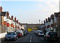
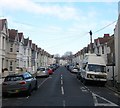
1
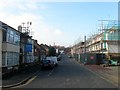
Kingsthorpe Road, Aldrington, Hove
A residential road that runs parallel to the railway and links School Road to Bolsover Road. Goodwood Court on the southern side to the left was built in the late 1930s, the two semi-detached buildings beyond were completed in the 1950s whilst the terrace beyond, known as The Forge replaced two older buildings of the same name, and appear to have been built in the last thirty years. On the northern side new houses are currently being built on the site of a builders yard whilst beyond are others which replaced a former sheet metal factory.
Image: © Simon Carey
Taken: 17 Dec 2016
0.02 miles
2
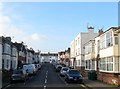
Dallington Road, Aldrington, Hove
A residential road that links School Road to Grange Road that was laid out on the 1911 and 1932 OS maps though building wasn't completed until the late 1930s.
Image: © Simon Carey
Taken: 17 Dec 2016
0.04 miles
3
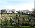
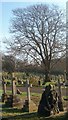
Hove Cemetery
The south eastern side of the cemetery located in a dip once known as Hangleton Bottom.
Hove Cemetery consists of two parts, the original section south of Old Shoreham Road that was first consecrated in 1882 and a second to the north of the road that opened in 1923 as an extension.
Image: © Simon Carey
Taken: 22 Jan 2017
0.06 miles
4
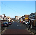
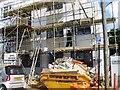
School Road, Aldrington, Hove
The road heads north from Portland Road ending at the junction with Kingsthorpe Road next to Rayford House, the large block in the distance. The western side abuts Hove Junior School and a couple of houses whilst the eastern side is largely made up of commercial buildings forming the Westerman Complex. Originally a builders yard that became home to a small works in the 1950s whose buildings were subdivided into four units housing a car accessories business and Westows, an indoor children's play area. There has been talk of demolishing these units and replacing them with housing.
Image: © Simon Carey
Taken: 17 Dec 2016
0.06 miles
5
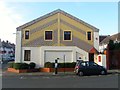
Express House, School Road, Aldrington, Hove
A small commercial unit on the corner of Milnthorpe Road built on the site of a builders yard.
Image: © Simon Carey
Taken: 17 Dec 2016
0.07 miles
6
Milnthorpe Road, Aldrington, Hove
A residential road that links Grange Road to School Road that had been laid out by the time of the 1911 OS map and had little development by the time of the 1932 edition. However, the road was completed by the end of the 1930s.
Image: © Simon Carey
Taken: 17 Dec 2016
0.07 miles
7
Nautical Grave, Hove Cemetery
A rock and anchor adorn the final resting place of a former member of the Royal Naval Volunteer Reserve next to the main avenue in the eastern section of the cemetery.
Hove Cemetery consists of two parts, the original section south of Old Shoreham Road that was first consecrated in 1882 and a second to the north of the road that opened in 1923 as an extension.
Image: © Simon Carey
Taken: 22 Jan 2017
0.07 miles
9
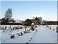
Hove Cemetery in the Snow
Opened in 1882 and covering 50 acres either side of the Old Shoreham Road. This looks back towards the entrance lodge on the A270.
Image: © Simon Carey
Taken: 7 Jan 2010
0.09 miles
10
Alpine Road, Aldrington, Hove
A residential road linking Stoneham Road to Payne Avenue that was built in the first decade of the 20th century.
Image: © Simon Carey
Taken: 17 Dec 2016
0.09 miles