IMAGES TAKEN NEAR TO
Wordsworth Street, HOVE, BN3 5BG
Introduction
This page details the photographs taken nearby to Wordsworth Street, BN3 5BG by members of the Geograph project.
The Geograph project started in 2005 with the aim of publishing, organising and preserving representative images for every square kilometre of Great Britain, Ireland and the Isle of Man.

There are currently over 7.5m images from over14,400 individuals and you can help contribute to the project by visiting https://www.geograph.org.uk
Image Map
Images are licensed for reuse under creativecommons.org/licenses/by-sa/2.0
Notes
- Clicking on the map will re-center to the selected point.
- The higher the marker number, the further away the image location is from the centre of the postcode.
Image Listing (113 Images Found)
Images are licensed for reuse under creativecommons.org/licenses/by-sa/2.0
Image
Details
Distance
2
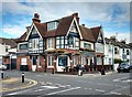
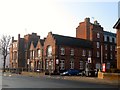
"The Poets' Corner" public house, Hove
Dated 1886.
Image: © Jim Osley
Taken: 8 Oct 2016
0.02 miles
3
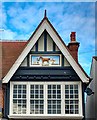
"The Poets' Corner" public house, Hove: decorated gable end
Image: © Jim Osley
Taken: 8 Oct 2016
0.03 miles
4
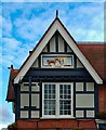
"The Poets' Corner" public house, Hove: decorated gable end
Image: © Jim Osley
Taken: 8 Oct 2016
0.04 miles
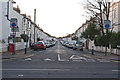
5
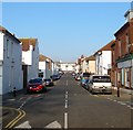
St Patricks Road, Hove
A residential street that originally linked Portland Road to Coleridge Street but has now been stopped up at the former. Built in the 1890s and located in the Poets Corner district of the city though not named after any.
Image: © Simon Carey
Taken: 17 Dec 2016
0.04 miles
6
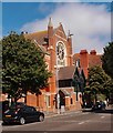
Hove Methodist Church, Portland Road
Grade II listed church building built in 1895 to the designs of architect John Wills. Architectural description at this https://historicengland.org.uk/listing/the-list/list-entry/1298647.
Image: © Jim Osley
Taken: 12 Aug 2016
0.05 miles
7
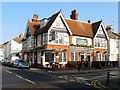
The Poets' Corner, Montgomery Street, Hove
Built as The Eclipse in 1886 and located on the corner of St Patrick's Road. The pubs original name derives from one of the horses visible in the gables, Eclipse, being a famous racehorse from the 18th century. The other horse was also well known in the 18th century and is called Diamond. The current name dates from 2010 and is named after the locals' name for the district it is located in.
Image: © Simon Carey
Taken: 22 Jan 2017
0.05 miles
8
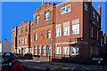
Flats in Montgomery Street, Hove, formerly a Hospital
Image: © Roger A Smith
Taken: 4 Nov 2012
0.05 miles
9
11, Portland Road, Hove
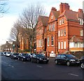
Built in 1892 and opened the following year as a police convalescent home to replace a smaller building that had originally opened in nearby Clarendon Villas in 1890. The building became an auxiliary hospital during World War One returning to its original use in 1919 and continuing in that role until 1966 when a new modern building was opened on the seafront at Kingsway, see Image The building was sold to East Sussex county Council who converted it into a nursing home which it has remained ever since now operating under the name of Middleton Grove.
Image: © Simon Carey
Taken: 14 Jan 2017
0.05 miles
10
Tennyson Court, Sackville Road, Hove
Located between Byron Street and Montgomery Street. The building was erected in 1887 as the Brighton, Hove and Preston Dispensary (Western Branch) and renamed Hove Hospital in 1918. Always cramped for space the hospital had an extension built in 1934 and moved into the nurses accommodation in 1946. However, the site became less suitable over time and closed the casualty department in 1970 and finally moved to a new site off Nevill Avenue in 1997. The block was subsequently converted into flats and given a name to match the neighbouring streets which is locally known as Poets Corner.
Image: © Simon Carey
Taken: 22 Jan 2017
0.06 miles