IMAGES TAKEN NEAR TO
Montgomery Street, HOVE, BN3 5BD
Introduction
This page details the photographs taken nearby to Montgomery Street, BN3 5BD by members of the Geograph project.
The Geograph project started in 2005 with the aim of publishing, organising and preserving representative images for every square kilometre of Great Britain, Ireland and the Isle of Man.

There are currently over 7.5m images from over14,400 individuals and you can help contribute to the project by visiting https://www.geograph.org.uk
Image Map
Images are licensed for reuse under creativecommons.org/licenses/by-sa/2.0
Notes
- Clicking on the map will re-center to the selected point.
- The higher the marker number, the further away the image location is from the centre of the postcode.
Image Listing (144 Images Found)
Images are licensed for reuse under creativecommons.org/licenses/by-sa/2.0
Image
Details
Distance
1

98a, Coleridge Street, Aldrington, Hove
Viewed from an entrance from Rutland Road. Inmans is an old established local auctioneer firm occupying what was once a former works.
Image: © Simon Carey
Taken: 22 Jan 2017
0.02 miles
3
Ancient Mariner Pub
In Rutland Road near Aldrington Station, details and reviews http://www.pubsgalore.co.uk/pubs/10962/
Image: © Paul Gillett
Taken: 21 Apr 2012
0.04 miles
5
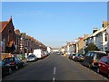
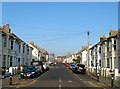
Rutland Road, Aldrington, Hove
A residential street that links Portland Road to the junction of Mortimer Road and Arthur Street. The eastern side was completed by 1898 with the western side built around the turn of the 20th century. On the left in the foreground is Rutland Hall.
Image: © Simon Carey
Taken: 17 Dec 2016
0.05 miles
6
Coleridge Street, Aldrington, Hove
The western section of the street located between Westbourne Street and Rutland Road that was developed in the 1890s and named after Samuel Taylor Coleridge. Beyond Westbourne Street the street heads east to Sackville Road, the A2023. Part of the district known locally as Poets Corner due to the street names as opposed to any bohemian tendencies.
Image: © Simon Carey
Taken: 17 Dec 2016
0.05 miles
7
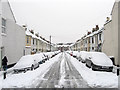
Wordsworth Street
Residential street linking Sackville Road to Rutland Road with this section looking towards the latter from the crossroads with Westbourne Street. Part of the district known as Poets Corner due to the road names rather than any wild bohemian lifestyle.
Image: © Simon Carey
Taken: 2 Dec 2010
0.05 miles
8
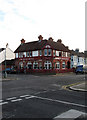
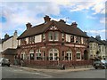
Ancient Mariner, Rutland Road
Though it is on the corner of Coleridge Street, once known as the Rutland the name change has only occurred in the last few years. Located in the area known as Poet's Corner due to the street names all being named after poets rather than anything resembling a Bohemian lifestyle. Much of the housing is terraced built for the tradesman who serviced the great and good in the villas between Portland Road and the sea. Taken from Rutland Road's junction with Molesworth Street.
Image: © Simon Carey
Taken: 14 Jan 2009
0.05 miles
9
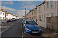
Westbourne Street, Aldrington, Hove
A residential street that connects Westbourne Gardens with Arthur Street that was built in the 1890s. Named after an ancient water filled ditch that once separated the parishes of Aldrington and Hove.
Image: © Simon Carey
Taken: 17 Dec 2016
0.06 miles
10
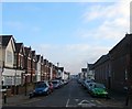
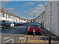
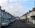
Montgomery Street, Aldrington, Hove
A residential street linking Tamworth Road to Sackville Road, the A2023. This is viewed from the junction with the former with the houses up to Rutland Road built in the first decade of the 20th century. The rest had been completed by 1898. Part of the Poets Corner district due to the street names rather than any bohemian tendencies with this one remembering Robert Montgomery, a largely forgotten 19th century poet, who died in Brighton in 1855.
Image: © Simon Carey
Taken: 17 Dec 2016
0.07 miles