IMAGES TAKEN NEAR TO
St. Leonards Road, HOVE, BN3 4QP
Introduction
This page details the photographs taken nearby to St. Leonards Road, BN3 4QP by members of the Geograph project.
The Geograph project started in 2005 with the aim of publishing, organising and preserving representative images for every square kilometre of Great Britain, Ireland and the Isle of Man.

There are currently over 7.5m images from over14,400 individuals and you can help contribute to the project by visiting https://www.geograph.org.uk
Image Map
Images are licensed for reuse under creativecommons.org/licenses/by-sa/2.0
Notes
- Clicking on the map will re-center to the selected point.
- The higher the marker number, the further away the image location is from the centre of the postcode.
Image Listing (167 Images Found)
Images are licensed for reuse under creativecommons.org/licenses/by-sa/2.0
Image
Details
Distance
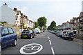
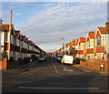
1
St Leonard's Road, Aldrington, Hove
A residential road that links Kingsway, the A259, to New Church Road, the B2066, that was begun in the late 1880s though not completed on the eastern side until the first decade of the 20th century.
Image: © Simon Carey
Taken: 22 Dec 2016
0.01 miles
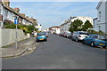
2
St Leonard's Avenue, Aldrington, Hove
A residential road linking Kingsway, the A259, to St Leonard's Road that was developed in the first decade of the 20th century and completed by the start of World War One. See Image for the northern section.
Image: © Simon Carey
Taken: 22 Dec 2016
0.02 miles
4
St Leonard's Avenue, Aldrington
Road laid out in the late 19th century which eventually filled in the vacant land between Portslade and Hove. Aldrington had been a parish in its own right but had been deserted from the middle ages and by the beginning of the 19th century consisted of a ruined church and a population of 3, the family of the local tollgate keeper.
Image: © Simon Carey
Taken: 14 Jan 2009
0.03 miles
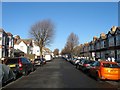
6
Erroll Road, Aldrington, Hove
A residential street that links Kingsway, the A259, to St Leonard's Avenue that was built around 1914.
Image: © Simon Carey
Taken: 22 Dec 2016
0.05 miles
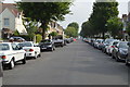
7
Seaford Road, Aldrington, Hove
A residential road that links St Leonard's Road to Boundary Road/Station Road, the B2194. The northern side was developed in the 1890s whilst the southern side was not completed until the first decade of the 20th century.
Image: © Simon Carey
Taken: 22 Dec 2016
0.06 miles
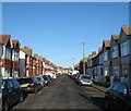
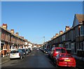
8

St Leonards Road
Housing in St Leonard's Road, dating mainly from the late 19th/early 20th Centuries, with some of those on the left and in the right background being shown on the 1899 6 inch map and others of those being first shown on the 1912 25 inch map. However the ones on the near right would appear to be slightly later, not shown until the 1930 edition.
Image: © Ian Capper
Taken: 21 Jan 2022
0.07 miles
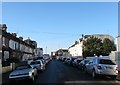
9

St Leonards Avenue
Housing in St Leonard's Avenue. Although maps suggest that this row of houses date from the c.1920s, being first shown on the 1930 25 inch map, most development of the road took place earlier, being marked on the 1912 edition
Image: © Ian Capper
Taken: 21 Jan 2022
0.07 miles