IMAGES TAKEN NEAR TO
St. Keyna Avenue, HOVE, BN3 4PN
Introduction
This page details the photographs taken nearby to St. Keyna Avenue, BN3 4PN by members of the Geograph project.
The Geograph project started in 2005 with the aim of publishing, organising and preserving representative images for every square kilometre of Great Britain, Ireland and the Isle of Man.

There are currently over 7.5m images from over14,400 individuals and you can help contribute to the project by visiting https://www.geograph.org.uk
Image Map
Images are licensed for reuse under creativecommons.org/licenses/by-sa/2.0
Notes
- Clicking on the map will re-center to the selected point.
- The higher the marker number, the further away the image location is from the centre of the postcode.
Image Listing (167 Images Found)
Images are licensed for reuse under creativecommons.org/licenses/by-sa/2.0
Image
Details
Distance
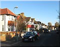
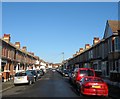
1
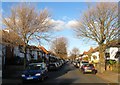
St Keyna Avenue, Aldrington, Hove
A residential road that lins Kingsway, the A259, to New Church Road, the B2066, that was developed in the late 1920s. St Keyna was a 5th century female saint who was born in Wales and later lived in the west country.
Image: © Simon Carey
Taken: 3 Dec 2016
0.02 miles
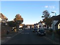
2
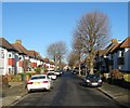
Middleton Avenue, Aldrington, Hove
A residential road that links Glastonbury Road to Kenton Road that was developed in the 1920s.
Image: © Simon Carey
Taken: 22 Dec 2016
0.03 miles
3
St Leonard's Gardens, Aldrington, Hove
A residential road that links Kingsway, the A259, to New Church Road, the B2066, that was developed in the 1930s.
Image: © Simon Carey
Taken: 22 Dec 2016
0.07 miles
4
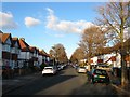
Derek Avenue, Aldrington, Hove
A residential road that links Kingsway, the A259, to New Church Road, the B2066. It was developed in the late 1920s.
Image: © Simon Carey
Taken: 3 Dec 2016
0.07 miles
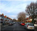
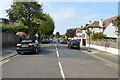
5
Kenton Road, Aldrington, Hove
A residential road that runs between Derek Avenue and St Keyna Avenue that was laid out in the 1920s but not developed until the following decade.
Image: © Simon Carey
Taken: 3 Dec 2016
0.08 miles
6
Glastonbury Road, Aldrington, Hove
A small residential road that links St Keyna Avenue to Derek Avenue that was developed in the 1920s though the houses on the southern side were not completed until the 1930s.
Image: © Simon Carey
Taken: 3 Dec 2016
0.09 miles
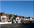
8
Erroll Mansions, Erroll Road, Aldrington, Hove
Two small blocks of flats at the northern end of Erroll Road beyond the point where it turns west to St Leonard's Avenue that were built in the 1930s. Beyond them is the newer Beacon House built in 1989 on the site on old council depot.
Image: © Simon Carey
Taken: 22 Dec 2016
0.11 miles
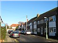
9
Erroll Road, Aldrington, Hove
A residential street that links Kingsway, the A259, to St Leonard's Avenue that was built around 1914.
Image: © Simon Carey
Taken: 22 Dec 2016
0.11 miles
10
345-367, Kingsway, Aldrington, Hove
A mixture of single and semi-detached properties located between St Keyna Avenue and Derek Avenue that were developed in the early 1930s.
Image: © Simon Carey
Taken: 22 Dec 2016
0.11 miles