1
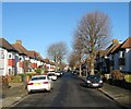
Middleton Avenue, Aldrington, Hove
A residential road that links Glastonbury Road to Kenton Road that was developed in the 1920s.
Image: © Simon Carey
Taken: 22 Dec 2016
0.02 miles
2
St Keyna Avenue, Aldrington, Hove
A residential road that lins Kingsway, the A259, to New Church Road, the B2066, that was developed in the late 1920s. St Keyna was a 5th century female saint who was born in Wales and later lived in the west country.
Image: © Simon Carey
Taken: 3 Dec 2016
0.04 miles
3
Derek Avenue, Aldrington, Hove
A residential road that links Kingsway, the A259, to New Church Road, the B2066. It was developed in the late 1920s.
Image: © Simon Carey
Taken: 3 Dec 2016
0.06 miles
4
Kenton Road, Aldrington, Hove
A residential road that runs between Derek Avenue and St Keyna Avenue that was laid out in the 1920s but not developed until the following decade.
Image: © Simon Carey
Taken: 3 Dec 2016
0.07 miles
5
Glastonbury Road, Aldrington, Hove
A small residential road that links St Keyna Avenue to Derek Avenue that was developed in the 1920s though the houses on the southern side were not completed until the 1930s.
Image: © Simon Carey
Taken: 3 Dec 2016
0.08 miles
6
St Leonard's Gardens, Aldrington, Hove
A residential road that links Kingsway, the A259, to New Church Road, the B2066, that was developed in the 1930s.
Image: © Simon Carey
Taken: 22 Dec 2016
0.09 miles
7
Brittany Road, Aldrington, Hove
A residential road that links Kingsway, the A259, to New Church Road, the B2066, that was built in the late 1920s.
Image: © Simon Carey
Taken: 22 Dec 2016
0.10 miles
8
St Keyna Avenue
Image: © N Chadwick
Taken: 4 Jul 2015
0.10 miles
9
Derek Avenue
Image: © N Chadwick
Taken: 4 Jul 2015
0.10 miles
10
345-367, Kingsway, Aldrington, Hove
A mixture of single and semi-detached properties located between St Keyna Avenue and Derek Avenue that were developed in the early 1930s.
Image: © Simon Carey
Taken: 22 Dec 2016
0.12 miles


