IMAGES TAKEN NEAR TO
Langdale Road, HOVE, BN3 4HN
Introduction
This page details the photographs taken nearby to Langdale Road, BN3 4HN by members of the Geograph project.
The Geograph project started in 2005 with the aim of publishing, organising and preserving representative images for every square kilometre of Great Britain, Ireland and the Isle of Man.

There are currently over 7.5m images from over14,400 individuals and you can help contribute to the project by visiting https://www.geograph.org.uk
Image Map
Images are licensed for reuse under creativecommons.org/licenses/by-sa/2.0
Notes
- Clicking on the map will re-center to the selected point.
- The higher the marker number, the further away the image location is from the centre of the postcode.
Image Listing (221 Images Found)
Images are licensed for reuse under creativecommons.org/licenses/by-sa/2.0
Image
Details
Distance
1
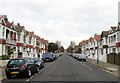
Langdale Road, Aldrington, Hove
A residential road that runs between Kingsway, the A259, and New Church Road, the B2066 that was built in the years leading up to the First World War.
Image: © Simon Carey
Taken: 14 Jan 2017
0.01 miles
2
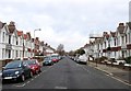
Langdale Gardens, Aldrington, Hove
A residential road that runs between Kingsway, the A259, and New Church Road, the B2066 that was built before 1914.
Image: © Simon Carey
Taken: 14 Jan 2017
0.05 miles
4
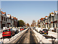
Langdale Road
Residential street linking Kingsway, the A259, with New Church Road, the B2066. The side roads were driveable a few hours after 10cm of snow had been deposited overnight but would prove to be far more dangerous on the following day when overnight freezing temperatures turned the slush and compacted snow into ice rinks.
Image: © Simon Carey
Taken: 18 Dec 2009
0.06 miles
6
Braemore House, Kingsway
Viewed from Western Esplanade with Langdale Gardens between it and a new development on the right.
Image: © Simon Carey
Taken: 14 Jan 2009
0.06 miles
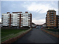
7
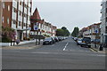
Flats at Hove, Sussex
Located on Kingsway, overlooking the Western Esplanade.
Image: © Peter Trimming
Taken: 17 Apr 2010
0.06 miles
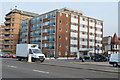
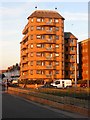
8
Langdale Court, Kingsway, Aldrington, Hove
Located on the corner of langdale Road and built in the 1960s on the site of a vacant plot and neighbouring number 225.
Image: © Simon Carey
Taken: 4 Dec 2016
0.06 miles
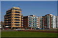
9
Prince of Wales Court, Kingsway, Aldrington, Hove
Located on the corner of Langdale Gardens with Image to the immediate east. Built in the late 1990s on the site of two former 1920s houses numbered 227 and 229.
Image: © Simon Carey
Taken: 4 Dec 2016
0.06 miles
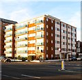
10
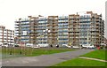
Channings, Kingsway, Aldrington, Hove
A large block of flats located between Carlisle Road and Langdale Gardens that were built in the early 1970s on the site of four large houses known collectively as Western Lawns, see http://regencysociety-jamesgray.com/volume15/source/jg_15_058.html and http://regencysociety-jamesgray.com/volume15/source/jg_15_055.html taken in 1967 and 1968 respectively.
Image: © Simon Carey
Taken: 14 Jan 2017
0.07 miles