IMAGES TAKEN NEAR TO
Braemore Road, HOVE, BN3 4HA
Introduction
This page details the photographs taken nearby to Braemore Road, BN3 4HA by members of the Geograph project.
The Geograph project started in 2005 with the aim of publishing, organising and preserving representative images for every square kilometre of Great Britain, Ireland and the Isle of Man.

There are currently over 7.5m images from over14,400 individuals and you can help contribute to the project by visiting https://www.geograph.org.uk
Image Map
Images are licensed for reuse under creativecommons.org/licenses/by-sa/2.0
Notes
- Clicking on the map will re-center to the selected point.
- The higher the marker number, the further away the image location is from the centre of the postcode.
Image Listing (213 Images Found)
Images are licensed for reuse under creativecommons.org/licenses/by-sa/2.0
Image
Details
Distance
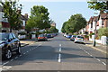
1
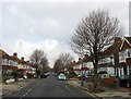
Braemore Road, Aldrington, Hove
A residential road that runs between Kingsway, the A259, and New Church Road, the B2066 that was built in the mid 1920s.
Image: © Simon Carey
Taken: 14 Jan 2017
0.04 miles
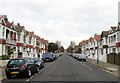
2
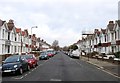
Langdale Gardens, Aldrington, Hove
A residential road that runs between Kingsway, the A259, and New Church Road, the B2066 that was built before 1914.
Image: © Simon Carey
Taken: 14 Jan 2017
0.05 miles
3
Berriedale Avenue, Aldrington, Hove
A residential road that links Kingsway, the A259, to New Church Road, the B2066 that was developed between 1926-27.
Image: © Simon Carey
Taken: 14 Dec 2016
0.07 miles
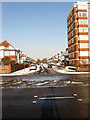
4
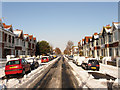
Langdale Road
Residential street linking Kingsway, the A259, with New Church Road, the B2066. The side roads were driveable a few hours after 10cm of snow had been deposited overnight but would prove to be far more dangerous on the following day when overnight freezing temperatures turned the slush and compacted snow into ice rinks.
Image: © Simon Carey
Taken: 18 Dec 2009
0.08 miles
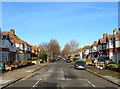
5
Langdale Road, Aldrington, Hove
A residential road that runs between Kingsway, the A259, and New Church Road, the B2066 that was built in the years leading up to the First World War.
Image: © Simon Carey
Taken: 14 Jan 2017
0.10 miles
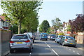
6
Braemore Road
The main seafront road, Kingsway, is at the end of the road, with a putting green (hidden) and beach huts beyond.
Image: © Robin Webster
Taken: 23 Mar 2010
0.10 miles
7
Braemore Road
Residential street linking Kingsway, the A259, with New Church Road, the B2066. Braemore House is the block of flats on the right.
Image: © Simon Carey
Taken: 18 Dec 2009
0.10 miles
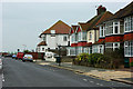
10
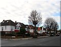
96-104, New Church Road, Aldrington, Hove
Individual houses located between Braemore Road and Berriedale Avenue and built in the mid 1920s.
Image: © Simon Carey
Taken: 14 Jan 2017
0.12 miles