IMAGES TAKEN NEAR TO
Princes Square, HOVE, BN3 4GE
Introduction
This page details the photographs taken nearby to Princes Square, BN3 4GE by members of the Geograph project.
The Geograph project started in 2005 with the aim of publishing, organising and preserving representative images for every square kilometre of Great Britain, Ireland and the Isle of Man.

There are currently over 7.5m images from over14,400 individuals and you can help contribute to the project by visiting https://www.geograph.org.uk
Image Map
Images are licensed for reuse under creativecommons.org/licenses/by-sa/2.0
Notes
- Clicking on the map will re-center to the selected point.
- The higher the marker number, the further away the image location is from the centre of the postcode.
Image Listing (191 Images Found)
Images are licensed for reuse under creativecommons.org/licenses/by-sa/2.0
Image
Details
Distance
1
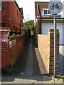
Footpath to Westbourne Place
From Princes Square.
Image: © Simon Carey
Taken: 22 Apr 2007
0.04 miles
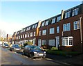
3
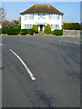
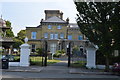
1 Princes Square
A little confusing as Princes Square is to the left of the house, the road in front being Princes Crescent as it turns west before heading south again. Princes Road veers to the right and heads to Hove Street. This part of Hove was developed from the early 20th century on former brickfields used to construct the grand estates of Brighton and Hove.
Image: © Simon Carey
Taken: 22 Apr 2007
0.05 miles
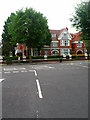
4
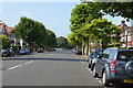
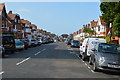
New Church Road
Looking east from the junction with Princes Square. New Church Road (B2066) links Hove with Portslade by Sea whilst travelling through Aldrington.
Image: © Simon Carey
Taken: 22 Apr 2007
0.05 miles
5
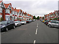
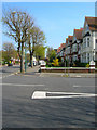
Aymer Road
Linking Princes Avenue with New Church Road is the first of a number of roads built on the site of former brickfields used to construct much of Victorian Hove.
Image: © Simon Carey
Taken: 1 Jul 2007
0.06 miles
9
19-35, Westbourne Place, Hove
Located at the north eastern end of Westbourne Place and officially in Hove as opposed to Aldrington, the old parish boundary between the two runs along the pavement. Built in the 1970s on the site of former garages built in 1929, see http://regencysociety-jamesgray.com/volume15/source/jg_15_110.html and http://regencysociety-jamesgray.com/volume15/source/jg_15_109.html
Image: © Simon Carey
Taken: 11 Dec 2016
0.07 miles
10
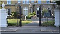
The Priory, New Church Road
Private hospital on the B2066 converted from early twentieth century townhouses.
Image: © Simon Carey
Taken: 1 Jul 2007
0.07 miles