IMAGES TAKEN NEAR TO
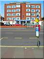
Princes Avenue, HOVE, BN3 4GD
Introduction
This page details the photographs taken nearby to Princes Avenue, BN3 4GD by members of the Geograph project.
The Geograph project started in 2005 with the aim of publishing, organising and preserving representative images for every square kilometre of Great Britain, Ireland and the Isle of Man.

There are currently over 7.5m images from over14,400 individuals and you can help contribute to the project by visiting https://www.geograph.org.uk
Image Map
Images are licensed for reuse under creativecommons.org/licenses/by-sa/2.0
Notes
- Clicking on the map will re-center to the selected point.
- The higher the marker number, the further away the image location is from the centre of the postcode.
Image Listing (251 Images Found)
Images are licensed for reuse under creativecommons.org/licenses/by-sa/2.0
Image
Details
Distance
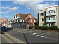
1
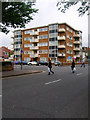
Princes Court
On the corner of Hove Street and Princes Avenue.
Image: © Simon Carey
Taken: 1 Jul 2007
0.03 miles
2
Flint Wall, Hove Street
All that remains of Hove Manor built in 1790 and demolished by the council in 1936. Hove Street was the original village street of Hove which a cluster of cottages, an inn and the manor stood. Today nothing remains of the original village except this wall.
Image: © Simon Carey
Taken: 1 Jan 2007
0.05 miles
3

Hove Manor, Hove Street
The name Hove Manor still exists but is for these flats and parade of shops rather than the original Georgian manor house.
Image: © Simon Carey
Taken: 1 Jan 2007
0.05 miles
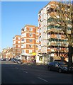
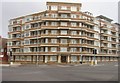
4
Viceroy Lodge
On the corner of Kingsway (A259) and Hove Street (A2023). Built in the late 1930s to augment the development of land to the west of Hove.
Image: © Simon Carey
Taken: 1 Jul 2007
0.05 miles
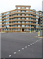
5
Hove Manor, Hove Street, Hove
Block of flats built in the 1930s on the site of the former Hove Manor that had been constructed in 1786 and demolished in 1933. See http://regencysociety-jamesgray.com/volume12/source/jg_12_153.html for a view taken in 1915, and http://regencysociety-jamesgray.com/volume12/source/jg_12_173.html for a view of the flats nearing completion in 1936.
Hove Street itself had been the old village street heading north from the beach to the Downs and had originally been narrow and possessing a bend. This disappeared in the 1920s when the street was widened and developed. In the process all the old 18th and 19th century buildings were demolished, the last going in the 1980s.
Image: © Simon Carey
Taken: 18 Feb 2017
0.05 miles
6
A block of flats, and the Ginger Pig restaurant, Hove Street, Hove
Image: © Ruth Sharville
Taken: 29 Sep 2023
0.06 miles
7
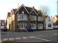
The Connaught, Hove Street
Erected in 1880 to serve the new estates being developed in the area.
Image: © Simon Carey
Taken: 1 Jan 2007
0.06 miles
8
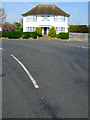
1 Princes Square
A little confusing as Princes Square is to the left of the house, the road in front being Princes Crescent as it turns west before heading south again. Princes Road veers to the right and heads to Hove Street. This part of Hove was developed from the early 20th century on former brickfields used to construct the grand estates of Brighton and Hove.
Image: © Simon Carey
Taken: 22 Apr 2007
0.06 miles
10
Princes Marine Hotel, Kingsway
Small non-descript hotel on the A259 opposite Western Lawns and the beach.
Image: © Simon Carey
Taken: 22 Apr 2007
0.07 miles