IMAGES TAKEN NEAR TO
Carlisle Road, HOVE, BN3 4FR
Introduction
This page details the photographs taken nearby to Carlisle Road, BN3 4FR by members of the Geograph project.
The Geograph project started in 2005 with the aim of publishing, organising and preserving representative images for every square kilometre of Great Britain, Ireland and the Isle of Man.

There are currently over 7.5m images from over14,400 individuals and you can help contribute to the project by visiting https://www.geograph.org.uk
Image Map
Images are licensed for reuse under creativecommons.org/licenses/by-sa/2.0
Notes
- Clicking on the map will re-center to the selected point.
- The higher the marker number, the further away the image location is from the centre of the postcode.
Image Listing (231 Images Found)
Images are licensed for reuse under creativecommons.org/licenses/by-sa/2.0
Image
Details
Distance
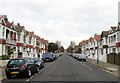
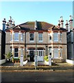
1
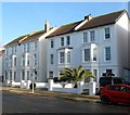
Carlisle Road, Aldrington, Hove
A residential road that runs between Kingsway, the A259, and New Church Road, the B2066 that was built in the 1890s. Its most famous resident was disgraced former MP Charles Stewart Parnell who died in a house in this street in 1891.
Image: © Simon Carey
Taken: 14 Jan 2017
0.02 miles
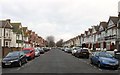
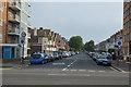
2
Langdale Road, Aldrington, Hove
A residential road that runs between Kingsway, the A259, and New Church Road, the B2066 that was built in the years leading up to the First World War.
Image: © Simon Carey
Taken: 14 Jan 2017
0.04 miles
3
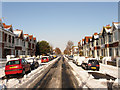
Langdale Road
Residential street linking Kingsway, the A259, with New Church Road, the B2066. The side roads were driveable a few hours after 10cm of snow had been deposited overnight but would prove to be far more dangerous on the following day when overnight freezing temperatures turned the slush and compacted snow into ice rinks.
Image: © Simon Carey
Taken: 18 Dec 2009
0.05 miles
4
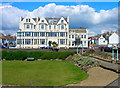
Girton House, Kingsway
Viewed from the Western Lawns. The vacant plot to the right is the site of the former Sackville Hotel built in 1904 and a favourite haunt of celebrities during the 50s and 60s. The hotel lost its lustre during the 70s and 80s and was reduced from 5 stars to 3 even becoming temporary council accommodation during the 90s. New owners planned to return the hotel to its former glory and undertook a massive rebuild but unfortunately the roof collapsed in April 2006 and destabilised the building enough for the residents of Girton House to be evacuated. The structure was pulled down not long after.
Image: © Simon Carey
Taken: 8 Jul 2007
0.07 miles
5
32-34, Walsingham Road, Aldrington, Hove
Part of a group (Numbers 18-48) of semi-detached houses built in the same style along the western side of the road sometime during the first decade of the 20th century.
Image: © Simon Carey
Taken: 11 Dec 2016
0.07 miles
7
Flats at Hove, Sussex
Located on Kingsway, overlooking the Western Esplanade.
Image: © Peter Trimming
Taken: 17 Apr 2010
0.08 miles
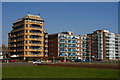
8
Channings and Dorset Court
Two apartment bocks on Kingsway, either side of Carlisle Road, seen across a hard play area on Western Lawns. Channings, consisting of 96 flats, was completed in 1971 and Dorset Court in 1957.
Image: © Ian Capper
Taken: 21 Jan 2022
0.08 miles
9
13-19, Walsingham Road, Aldrington, Hove
The surviving three storey houses at the south eastern end of the road that were built in the 1890s. Numbers 1-11 were lost to the construction of Image
Image: © Simon Carey
Taken: 11 Dec 2016
0.08 miles
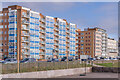
10
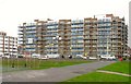
Channings, Kingsway, Aldrington, Hove
A large block of flats located between Carlisle Road and Langdale Gardens that were built in the early 1970s on the site of four large houses known collectively as Western Lawns, see http://regencysociety-jamesgray.com/volume15/source/jg_15_058.html and http://regencysociety-jamesgray.com/volume15/source/jg_15_055.html taken in 1967 and 1968 respectively.
Image: © Simon Carey
Taken: 14 Jan 2017
0.08 miles