IMAGES TAKEN NEAR TO
Blatchington Road, HOVE, BN3 3YP
Introduction
This page details the photographs taken nearby to Blatchington Road, BN3 3YP by members of the Geograph project.
The Geograph project started in 2005 with the aim of publishing, organising and preserving representative images for every square kilometre of Great Britain, Ireland and the Isle of Man.

There are currently over 7.5m images from over14,400 individuals and you can help contribute to the project by visiting https://www.geograph.org.uk
Image Map
Images are licensed for reuse under creativecommons.org/licenses/by-sa/2.0
Notes
- Clicking on the map will re-center to the selected point.
- The higher the marker number, the further away the image location is from the centre of the postcode.
Image Listing (167 Images Found)
Images are licensed for reuse under creativecommons.org/licenses/by-sa/2.0
Image
Details
Distance
2
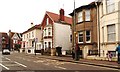
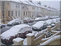
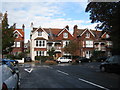
Blatchington Road, Hove
A road that runs east from Sackville Road, the A2023, becoming Eaton Road at the junction with Denmark Villas. These houses were built in the 1860s and remain in the most cases residential despite the southern side being overwhelmingly commercial in nature.
Image: © Simon Carey
Taken: 14 Jan 2017
0.05 miles
3
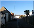
Brooker Place, Hove
A cul de sac off Stirling Place which consists largely of garages with the exception of the house at the end. The houses on the right front onto Image
Image: © Simon Carey
Taken: 18 Feb 2017
0.06 miles
4
Brooker Street, Hove
A residential street linking Stirling Place to Blatchington Road that was developed in the early 1880s.
Image: © Simon Carey
Taken: 18 Feb 2017
0.06 miles
6
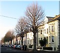
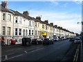
Clarendon Villas, Hove
A view of the block of semi-detached villas that are located between Goldstone Street and Sackville Road that were built in the 1880s.
Image: © Simon Carey
Taken: 17 Dec 2016
0.07 miles
7
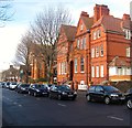
11, Portland Road, Hove
Built in 1892 and opened the following year as a police convalescent home to replace a smaller building that had originally opened in nearby Clarendon Villas in 1890. The building became an auxiliary hospital during World War One returning to its original use in 1919 and continuing in that role until 1966 when a new modern building was opened on the seafront at Kingsway, see Image The building was sold to East Sussex county Council who converted it into a nursing home which it has remained ever since now operating under the name of Middleton Grove.
Image: © Simon Carey
Taken: 14 Jan 2017
0.10 miles
8
Goldstone Road, Hove
A residential street that links Sackville Road, the A2023, to Goldstone Villas that was built in the 1870s.
Image: © Simon Carey
Taken: 17 Dec 2016
0.10 miles
9
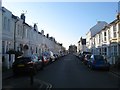
Houses on Pembroke Crescent
Looking from junction with Pembroke Avenue.
Image: © Oast House Archive
Taken: 16 Oct 2010
0.10 miles
10
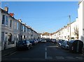
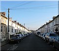
Stirling Place, Hove
A residential street that runs between Belfast Street and Sackville Road, the A2023 that was developed in the early 1880s.
Image: © Simon Carey
Taken: 18 Feb 2017
0.12 miles