IMAGES TAKEN NEAR TO
Denmark Mews, HOVE, BN3 3TX
Introduction
This page details the photographs taken nearby to Denmark Mews, BN3 3TX by members of the Geograph project.
The Geograph project started in 2005 with the aim of publishing, organising and preserving representative images for every square kilometre of Great Britain, Ireland and the Isle of Man.

There are currently over 7.5m images from over14,400 individuals and you can help contribute to the project by visiting https://www.geograph.org.uk
Image Map (Loading...)


Getting Data...Please wait
Leaflet Map data © OpenStreetMap
Images are licensed for reuse under creativecommons.org/licenses/by-sa/2.0
Notes
- Clicking on the map will re-center to the selected point.
- The higher the marker number, the further away the image location is from the centre of the postcode.
Image Listing (204 Images Found)
Images are licensed for reuse under creativecommons.org/licenses/by-sa/2.0
Image
Details
Distance

2
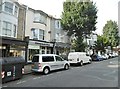
Hove, Watchmaker's Arms
Good Beer Guide-listed micropub on Goldstone Villas (with the pennants). Narrow premises, with counter back right, and drinking area front and left. Five cask ales were on offer at my visit. So called because the property was at one time a watchmaker's shop.
Image: © Mike Faherty
Taken: 15 Sep 2018
0.05 miles
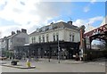
3
Council Offices, Denmark Villas
This building is at the very edge of the grid square, in fact the line runs through the middle of the house at the far end. This piece of land has a fair history, it was first built on in 1921 when an Ice Rink was erected on the site. This went bust and was taken over by the Odeon Cinema chain in 1929 and converted into a cinema. The cinema itself lasted until 1961 when that too was closed down and the building was converted for a second time to a bowling alley. Unfortunately, the alley had to contend with competition from nearby King Alfred Leisue Complex and succumbed in 1969. This time the building did not survive being demolished and converted into Council offices. Underneath the offices are a small car repair centre, a health club and a Tesco Express, one of two in this grid square.
Image: © Simon Carey
Taken: 22 Apr 2006
0.05 miles
4
The Station Pub, Hove
Opposite Hove Station http://www.thestationhove.co.uk/
Image: © Paul Gillett
Taken: 7 Feb 2014
0.06 miles
6
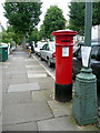
Anonymous Pillar Box, Denmark Villas, Hove, East Sussex
Looking south from the east side of Denmark Villas. Image]
Image: © Christine Matthews
Taken: 11 Jul 2009
0.06 miles
7
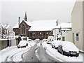
St Barnabas Church
Located on the corner of Sackville Road and Coleridge Street though this view is from Sheridan Terrace. It was consecrated in 1883 to serve the growing area around Conway Street and the soon to be built Poets Corner. Prior to the church being built the land was allotments and before that a field which was a popular stopping place for gypsies.
Image: © Simon Carey
Taken: 2 Dec 2010
0.06 miles
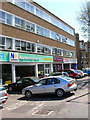
8
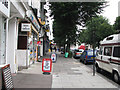
Hove: on the way to the station
Goldstone Villas shops.
Image: © John Sutton
Taken: 5 Aug 2009
0.06 miles
9
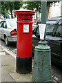
Anonymous Pillar Box, Denmark Villas, Hove, East Sussex
Pillar boxes erected from 1879 for approximately 13 years were called anonymous as there was no royal cypher or Post Office sign on them.
Image: © Christine Matthews
Taken: 11 Jul 2009
0.07 miles
10
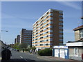
Clarendon Road, Hove
Blocks of flats on Clarendon Road, Hove.
Image: © Malc McDonald
Taken: 10 Apr 2011
0.07 miles