IMAGES TAKEN NEAR TO
Eaton Villas, HOVE, BN3 3TB
Introduction
This page details the photographs taken nearby to Eaton Villas, BN3 3TB by members of the Geograph project.
The Geograph project started in 2005 with the aim of publishing, organising and preserving representative images for every square kilometre of Great Britain, Ireland and the Isle of Man.

There are currently over 7.5m images from over14,400 individuals and you can help contribute to the project by visiting https://www.geograph.org.uk
Image Map
Images are licensed for reuse under creativecommons.org/licenses/by-sa/2.0
Notes
- Clicking on the map will re-center to the selected point.
- The higher the marker number, the further away the image location is from the centre of the postcode.
Image Listing (192 Images Found)
Images are licensed for reuse under creativecommons.org/licenses/by-sa/2.0
Image
Details
Distance
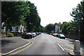
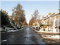
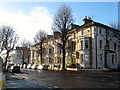
1

Eaton Villas, Hove, East Sussex
As seen from the junction with Denmark Villas.
Image: © Christine Matthews
Taken: 11 Jul 2009
0.02 miles
3
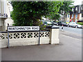
Blatchington Road, Hove, East Sussex
North-west corner of Blatchington Road at junction with Denmark Villas.
Image: © Christine Matthews
Taken: 11 Jul 2009
0.03 miles
5
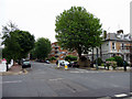
Junction of Denmark Villas and Eaton Villas, Hove, East Sussex
As seen from the south-west.
Image: © Christine Matthews
Taken: 11 Jul 2009
0.03 miles
6
Denmark Villas
Residential road linking Blatchington Road with Hove Station becoming the B2120 towards its northern end. Taken from the junction with Eaton Gardens.
Image: © Simon Carey
Taken: 18 Dec 2009
0.03 miles
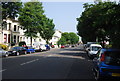
7
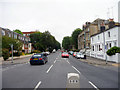
Eaton Road, Hove, East Sussex
Looking east down Eaton Road from near the junction with Denmark Villas.
Image: © Christine Matthews
Taken: 11 Jul 2009
0.03 miles
8
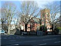
Holy Trinity Church, Hove
Holy Trinity Church is a former Anglican church in Hove, Built in the early 1860s to provide extra capacity for Anglican worshippers in the rapidly growing town of Hove, its use declined in the 20th century and it was closed in 2007 following a Diocesan review. As of 2009, its future is uncertain, and a heritage group has described it as one of Britain's top ten threatened Victorian and Edwardian buildings. The church has Grade II listed status, reflecting its architectural and historic importance. http://en.wikipedia.org/wiki/Holy_Trinity_Church,_Hove
Image: © Paul Gillett
Taken: 8 Feb 2013
0.03 miles
9
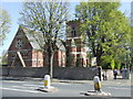
Holy Trinity church, Hove
The Holy Trinity church building dates from the 1860s, a time when the town of Hove was expanding rapidly. The church closed in 2008.
The building is now threatened with demolition, with plans to build housing on the site.
Image: © Malc McDonald
Taken: 10 Apr 2011
0.04 miles
10
1-13, Denmark Villas, Hove
This small block is located between Eaton Villas and Blatchington Road and was built around the 1860s and originally known as Hova Terrace on the 1879 and 1898 OS maps.
Image: © Simon Carey
Taken: 11 Dec 2016
0.04 miles