IMAGES TAKEN NEAR TO
Sackville Road, HOVE, BN3 3HD
Introduction
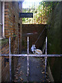
This page details the photographs taken nearby to Sackville Road, BN3 3HD by members of the Geograph project.
The Geograph project started in 2005 with the aim of publishing, organising and preserving representative images for every square kilometre of Great Britain, Ireland and the Isle of Man.

There are currently over 7.5m images from over14,400 individuals and you can help contribute to the project by visiting https://www.geograph.org.uk
Image Map
Images are licensed for reuse under creativecommons.org/licenses/by-sa/2.0
Notes
- Clicking on the map will re-center to the selected point.
- The higher the marker number, the further away the image location is from the centre of the postcode.
Image Listing (141 Images Found)
Images are licensed for reuse under creativecommons.org/licenses/by-sa/2.0
Image
Details
Distance
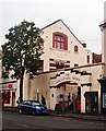
2
Sackville Road
The A2023 that runs between the A259 and the A2038. Originally an ancient route that linked the small settlement of Hove with the Downs it was known as Hove Drove until changed to the current name in 1880. The girder bridge in the distance carrying the railway over the road was built in 1927 to replace the original narrow brick arch construction which was deemed too narrow to cope with existing traffic.
Image: © Simon Carey
Taken: 2 Dec 2010
0.01 miles
3
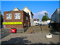
Conway Place
Looking up the steps towards the cul-de-sac. The A2023 is to the left of the off licence.
Image: © Simon Carey
Taken: 14 Oct 2007
0.02 miles
4
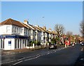
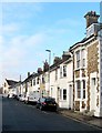
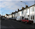
90-114, Sackville Road, Hove
A terrace of houses located north of the junction with Coleridge Street that were built in the mid 1880s.
Image: © Simon Carey
Taken: 22 Jan 2017
0.02 miles
5
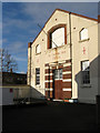
Salvation Army Citadel, Sackville Road
Sackville Road is down the stairs to the left. The citadel opened in 1880 and is still used today.
Image: © Simon Carey
Taken: 14 Jan 2009
0.03 miles
6
101-133, Conway Street, Hove
Built in the late 1970s and the only surviving dwellings from that period on Conway Street, all the other housing was swept away in the late 1960s in a large scale development that encompassed near enough all buildings between Clarendon Road and the railway. The large building at the far end is the Salvation Army Citadel.
Image: © Simon Carey
Taken: 17 Dec 2016
0.03 miles
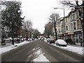
7
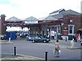
Hove station
looking west, with Goldstone Villas to the left
Image: © Andrew Longton
Taken: 7 Aug 2005
0.03 miles
8
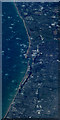
Shoreham-by-sea and the south coast from the air
Coral greyhound stadium Image can be seen in the foreground. Taken from a Paris bound flight from Glasgow.
Image: © Thomas Nugent
Taken: 30 Aug 2016
0.03 miles
9
Former Public Lavatory, Sackville Road
Built into the ground floor of a block of flats erected during the 1960s on the western side of Sackville Road leading up to the railway bridge. The ladies front out onto the road whilst the gents was round the corner down an alley. Neither are in use anymore.
Image: © Simon Carey
Taken: 14 Oct 2007
0.03 miles
10
Conway Place
Small cul-de-sac off Conway Street which travels west then turns south at the junction just in view. One of the few remaining areas of housing between Clarendon Road and the railway much of which was removed in the 1960s and replaced with warehouses and blocks of flats.
Image: © Simon Carey
Taken: 14 Jan 2009
0.05 miles