IMAGES TAKEN NEAR TO
St. Johns Road, HOVE, BN3 2FX
Introduction
This page details the photographs taken nearby to St. Johns Road, BN3 2FX by members of the Geograph project.
The Geograph project started in 2005 with the aim of publishing, organising and preserving representative images for every square kilometre of Great Britain, Ireland and the Isle of Man.

There are currently over 7.5m images from over14,400 individuals and you can help contribute to the project by visiting https://www.geograph.org.uk
Image Map
Images are licensed for reuse under creativecommons.org/licenses/by-sa/2.0
Notes
- Clicking on the map will re-center to the selected point.
- The higher the marker number, the further away the image location is from the centre of the postcode.
Image Listing (428 Images Found)
Images are licensed for reuse under creativecommons.org/licenses/by-sa/2.0
Image
Details
Distance
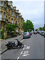
1
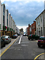
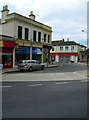
St John's Road
The road marks the boundary between two different developments in Hove, Adelaide Crescent/Palmeira Square to the east and the Avenues to the west. Originally a service road for the former now a back road with some businesses and new developments.
Image: © Simon Carey
Taken: 2 Sep 2007
0.01 miles
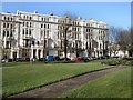
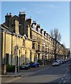
2
First Avenue - Eastern Side
The Avenues (First to Fourth plus Grand) were the last part of the coastal strip between Brighton and Hove to be built. First Avenue was the earliest to be constructed but slow house sales meant that architectural styles had changed by the time they reached Fourth Avenue further west. This view looks northwards towards the junction with Church Road.
Image: © Simon Carey
Taken: 1 Jul 2007
0.02 miles
3
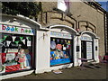
Book Nook
Children's bookshop in First Avenue, Hove. https://booknookuk.com/
Image: © Paul Gillett
Taken: 21 Mar 2020
0.03 miles
4
Entrance to St John's Road
Image] is out of picture to the right. The road comes off the one way system (B2066) around the floral clock and leads to the sea.
Image: © Simon Carey
Taken: 2 Sep 2007
0.04 miles
5
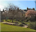
Cornerstone Centre garden
Cornerstone is a community centre located in central Hove at the corner of First Avenue and Church Road, The Centre is the result of a joint project between local residents and the congregation of St. John The Baptist Church. Work began in 1989 with the construction of a three-floored building within the nave of the church. Since that early stage, Cornerstone has grown considerably and it is now a very busy centre, hosting over fifty groups a week. http://www.cornerstone-hove.org.uk/
Image: © Paul Gillett
Taken: 10 Apr 2010
0.04 miles
6
Palmeira Court, Palmeira Square
This is the western side. See Image] for the story of its construction.
Image: © Simon Carey
Taken: 2 Sep 2007
0.04 miles
7
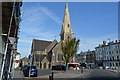
Church of St John the Baptist
Grade II listed. http://www.britishlistedbuildings.co.uk/en-365515-church-of-st-john-the-baptist-
Image: © N Chadwick
Taken: 4 Jul 2015
0.04 miles
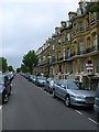
8
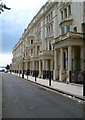
First Avenue - Western Side
Looking north towards the junction with Church Road. Like other roads in the vicinity First Avenue is wide enough to be able to accommodate double bank parking in the centre of the road.
Image: © Simon Carey
Taken: 1 Jul 2007
0.04 miles
9
First Avenue, Hove
A view of the eastern side of First Avenue that was constructed during the 1870s. Many of these old townhouses are now subdivided into flats and bedsits.
Image: © Simon Carey
Taken: 9 Apr 2020
0.05 miles