IMAGES TAKEN NEAR TO
Hove Street, HOVE, BN3 2DN
Introduction
This page details the photographs taken nearby to Hove Street, BN3 2DN by members of the Geograph project.
The Geograph project started in 2005 with the aim of publishing, organising and preserving representative images for every square kilometre of Great Britain, Ireland and the Isle of Man.

There are currently over 7.5m images from over14,400 individuals and you can help contribute to the project by visiting https://www.geograph.org.uk
Image Map
Images are licensed for reuse under creativecommons.org/licenses/by-sa/2.0
Notes
- Clicking on the map will re-center to the selected point.
- The higher the marker number, the further away the image location is from the centre of the postcode.
Image Listing (218 Images Found)
Images are licensed for reuse under creativecommons.org/licenses/by-sa/2.0
Image
Details
Distance
1
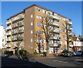
Dolphin Court, Hove Street, Hove
Located on the corner of Vallance Road and built in the 1960s on what was empty land.
Image: © Simon Carey
Taken: 18 Feb 2017
0.01 miles
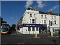
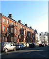
3
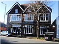
The Connaught Pub, Hove
In Hove Street
Image: © Paul Gillett
Taken: 14 Nov 2012
0.03 miles
4
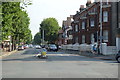
The junction of Hove Street and (opposite) Sackville Road with Church Road, Hove
Hove Street, becoming Sackville Road, is the A 2023. Church Road is the B2066.
Image: © Ruth Sharville
Taken: 29 Sep 2023
0.03 miles
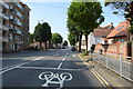
6
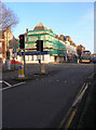
A2023/B2066 Crossroads, Hove
Where the A2023 (north-south) meets the B2066 (east-west). Clockwise; Sackville Road heads north, Church Road east, Hove Street south and New Church Road west. This point also marks the western most edge of Hove's shopping area.
Image: © Simon Carey
Taken: 1 Jan 2007
0.04 miles
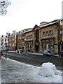
7
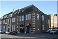
Hove old fire station, Hove Street
Hove old fire station, Hove Street, Hove, East Sussex
Image: © Kevin Hale
Taken: 9 Nov 2009
0.05 miles
8
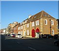
Audley House/Regent House/Vallance House, Hove Street, Hove
Three buildings located between Image to the south and Vallance Road to the north that were built around 1926. Audley House to the left was a purpose built fire station that replaced former premises in George Street and remained in operation until 1976 when it moved to its current site in English Close, see http://regencysociety-jamesgray.com/volume12/source/jg_12_177.html for a view of the station in 1928. The building was converted into flats in 1981. Regent House in the middle was originally an electricity sub-station and is now combined offices and flats. Vallance House at the northern end to the left was originally a sorting office for the Royal Mail but has been converted into offices occupied by a solicitors practice since 2006. Previously the site had been part of a farm, see http://regencysociety-jamesgray.com/volume12/source/jg_12_157.html for a view from the north taken in 1914.
Image: © Simon Carey
Taken: 18 Feb 2017
0.05 miles
9
5-11, Sackville Road, Hove
Just to the north of the junction with Church Road and built in the 1880s when Sackville Road began to be developed. Previously it had been an old droveway known as Hove Drove.
Image: © Simon Carey
Taken: 18 Feb 2017
0.05 miles
10
Hove Library
Located on Church Road opposite the new Tesco and built in 1908, it recently celebrated its centenary.
Image: © Simon Carey
Taken: 18 Dec 2009
0.06 miles