IMAGES TAKEN NEAR TO
York Avenue, HOVE, BN3 1PT
Introduction
This page details the photographs taken nearby to York Avenue, BN3 1PT by members of the Geograph project.
The Geograph project started in 2005 with the aim of publishing, organising and preserving representative images for every square kilometre of Great Britain, Ireland and the Isle of Man.

There are currently over 7.5m images from over14,400 individuals and you can help contribute to the project by visiting https://www.geograph.org.uk
Image Map
Images are licensed for reuse under creativecommons.org/licenses/by-sa/2.0
Notes
- Clicking on the map will re-center to the selected point.
- The higher the marker number, the further away the image location is from the centre of the postcode.
Image Listing (288 Images Found)
Images are licensed for reuse under creativecommons.org/licenses/by-sa/2.0
Image
Details
Distance
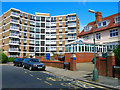
1
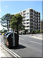
Furze Hill Court
Block of flats on the corner of Furze Hill and York Avenue.
Image: © Simon Carey
Taken: 30 Jul 2009
0.01 miles
2
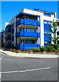
York Mansions
Continue up Norfolk Terrace then turn west into Temple Gardens, keep going until you reach the crossroads with York Avenue. York Mansions is on the north east side of that crossroads and was constructed in 2002 on the site of a former hospital that was opened in 1844 and demolished in 2000.
Click on the link to take you to the next page. http://www.geograph.org.uk/photo/211796
Image: © Simon Carey
Taken: 30 Jul 2006
0.02 miles
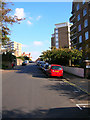
3
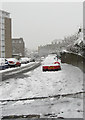
Furze Hill
Running through what was once the grounds of Wick Manor, it links York Avenue with Lansdowne Road. Furze Hill Court is on the immediate left followed by Wick Hall whilst Furze Croft is in the distance on the right.
Image: © Simon Carey
Taken: 2 Feb 2009
0.03 miles
4
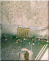
Old Boundary Marker by Temple Gardens, Brighton parish
Parish Boundary Marker by the UC road, in parish of Brighton (Brighton and Hove District), Temple Gardens, partially inset into wall next to car park entrance.
Inscription reads:-
B|H
Surveyed
Milestone Society National ID: SX_BNHV05pb
Image: © Milestone Society
Taken: Unknown
0.05 miles
5
Furze Hill House
Having left the park turn left up Furze Hill towards the junction with York Avenue. We are still in Hove and in the area once part of Wick Hall now a number of blocks of flats. This one was constructed in the 1960s.
Click on the link to take you to the next slide. http://www.geograph.org.uk/photo/211398
Image: © Simon Carey
Taken: 30 Jul 2006
0.05 miles
6
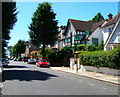
York Avenue
Continue travelling up the northern part of York Avenue. This area was built up in the early part of the twentieth century the road itself being a hotchpotch of architectural styles.
Click on the link to take you to the next page. http://www.geograph.org.uk/photo/211799
Image: © Simon Carey
Taken: 30 Jul 2006
0.05 miles
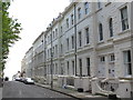
7
Furze Hill
A road through the former Wick Estate connecting Lansdowne Road with York Avenue. The part of the building on the right is Wick Hall with the more modern Furze Hill Court further up the hill.
Image: © Simon Carey
Taken: 21 Oct 2007
0.06 miles
10
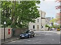
Temple Gardens, BN1
Shows the location of Image
Image: © Mike Quinn
Taken: 16 May 2012
0.06 miles