IMAGES TAKEN NEAR TO
Furze Hill, HOVE, BN3 1PB
Introduction
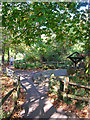
This page details the photographs taken nearby to Furze Hill, BN3 1PB by members of the Geograph project.
The Geograph project started in 2005 with the aim of publishing, organising and preserving representative images for every square kilometre of Great Britain, Ireland and the Isle of Man.

There are currently over 7.5m images from over14,400 individuals and you can help contribute to the project by visiting https://www.geograph.org.uk
Image Map
Images are licensed for reuse under creativecommons.org/licenses/by-sa/2.0
Notes
- Clicking on the map will re-center to the selected point.
- The higher the marker number, the further away the image location is from the centre of the postcode.
Image Listing (221 Images Found)
Images are licensed for reuse under creativecommons.org/licenses/by-sa/2.0
Image
Details
Distance
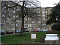
1
Furze Croft
Built in 1936 as a luxury development on the site of a former Victorian prep school. Still has a certain prestige attached to living here today.
Image: © Simon Carey
Taken: 21 Oct 2007
0.01 miles
2
Furze Croft
Situated South of St Ann's Well gardens, Furze Croft was built in 1936 and has been described as being like an art deco ocean liner
Image: © Paul Gillett
Taken: 31 Jan 2010
0.01 miles
3
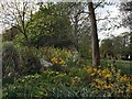
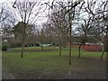
St Ann's Well Gardens
Opened as a public park in 1908 prior to that it was part of a spa based around Image as well as part of the grounds of Wick Manor.
Image: © Simon Carey
Taken: 18 Jan 2013
0.02 miles
4
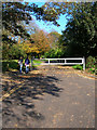
Entrance, St Ann's Well Gardens
Southern entrance from Furze Hill. See http://www.mybrightonandhove.org.uk/page_id__7600_img__10104_path__0p114p127p1380p.aspx for a 1912 view.
Image: © Simon Carey
Taken: 21 Oct 2007
0.03 miles
6
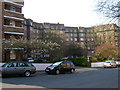
Wick Hall, North Side
Built in 1936 on the site of a former mansion built in the 1840s by Decimus Burton. The council was sold the original property in the early 1930s but couldn't find a use for it so demolished it and built these flats instead.
See Image] for the southern view.
Image: © Simon Carey
Taken: 2 Apr 2007
0.04 miles
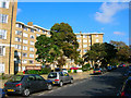
7
Furze Hill
The flats on the left are Wick Hall whilst those on the right are Furze Croft, the latter built on the site of Wick Farm.
Image: © Simon Carey
Taken: 18 Jan 2013
0.05 miles
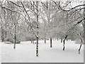
8
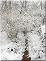
Former Chalybeate, St Ann's Well Gardens
A spring has existed here for many centuries and was non-descript until the 18th century when the water table rose and the water emerged with greater force. Local entrepreneurs set up a spa and the place prospered until the waters began diminishing in the 19th century. The stream is often difficult to see in most seasons, however, today's snow has enabled a greater contrast and highlighted the rusty red colour of the trickle of water.
Image: © Simon Carey
Taken: 18 Jan 2013
0.05 miles
9
St Ann's Well Gardens
The replica well marks the spot of the chalybeate spring which still trickles through the park to the pond. During the 18th century the spring began gushing forth greater torrents of water at a time when health spas were becoming fashionable. A pump house was built on the site in 1800 (See http://www.mybrightonandhove.org.uk/page_id__7600_img__10106_path__0p114p127p1380p.aspx for an old postcard) which remained until pulled down in 1935. By then other wells sunk in the area had reduced the stream to a trickle again.
Image: © Simon Carey
Taken: 21 Oct 2007
0.05 miles
10
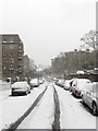
St Ann's Well Gardens in Winter
Viewed from the South near Furze Hill
Image: © Paul Gillett
Taken: 31 Jan 2010
0.05 miles