IMAGES TAKEN NEAR TO
Lansdowne Place, HOVE, BN3 1FP
Introduction
This page details the photographs taken nearby to Lansdowne Place, BN3 1FP by members of the Geograph project.
The Geograph project started in 2005 with the aim of publishing, organising and preserving representative images for every square kilometre of Great Britain, Ireland and the Isle of Man.

There are currently over 7.5m images from over14,400 individuals and you can help contribute to the project by visiting https://www.geograph.org.uk
Image Map
Images are licensed for reuse under creativecommons.org/licenses/by-sa/2.0
Notes
- Clicking on the map will re-center to the selected point.
- The higher the marker number, the further away the image location is from the centre of the postcode.
Image Listing (316 Images Found)
Images are licensed for reuse under creativecommons.org/licenses/by-sa/2.0
Image
Details
Distance
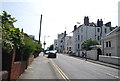
1
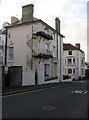
Fire Escape, Lansdowne Road
Originally built as town houses many of the Victorian terraces have been subdivided into flats. A tragedy in nearby Hove Villas in the mid 1990s when a number of people lost their lives when a fire spread through a top floor flat holding a party caused the council to get tough and order fire escapes from every multi-occupied building in the city, listed or not. This house is on the junction of Lansdowne Road and Lansdowne Street.
Image: © Simon Carey
Taken: 4 Nov 2007
0.01 miles
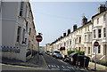
2
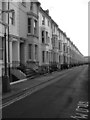
Lansdowne Street
Connecting Lansdowne Road to Western Road and built in the 1850s as lower cost housing in the Brunswick Town development. The terraces are now listed.
Image: © Simon Carey
Taken: 4 Nov 2007
0.02 miles
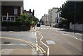
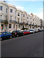
3
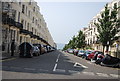
Lansdowne Place
The buildings on the left are all Grade II listed. http://www.britishlistedbuildings.co.uk/en-365579-nos-52-118-including-walls-and-railings-
Image: © N Chadwick
Taken: 13 Jul 2013
0.03 miles
4
Synagogue, Lansdowne Road
One of three in this grid square and a reminder of the influence of the 19th century landowner, Sir Isaac Goldsmit who developed this area.
Image: © Simon Carey
Taken: 3 Jun 2007
0.03 miles
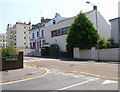
8
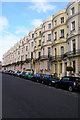
Lansdowne Place (Eastern Side)
Bow fronted terraced Victorian town houses erected during the 1850s as lower cost housing to the more upmarket Brunswick Square nearby. This part of Lansdowne Place is between Western Road and Lansdowne Road.
Image: © Simon Carey
Taken: 4 Nov 2007
0.04 miles
9
Lansdowne Place (Western Side)
Bow fronted terraced Victorian town houses erected during the 1850s as lower cost housing to the more upmarket Brunswick Square nearby. This part of Lansdowne Place is between Western Road and Lansdowne Road.
Image: © Simon Carey
Taken: 4 Nov 2007
0.04 miles
10
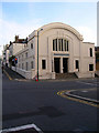
Hove Hebrew Congregation Synagogue, Holland Road
One of three synagogues in this grid square. This is on the corner of Holland Road and Lansdowne Road, both named after Lords who supported Jewish emancipation in the 19th century and both friends of Sir Isaac Goldsmid, a rich Jewish financier who lived in nearby Wick Manor and owned much of the land developed in the vicinity.
Image: © Simon Carey
Taken: 4 Nov 2007
0.05 miles