IMAGES TAKEN NEAR TO
Brunswick Place, HOVE, BN3 1EA
Introduction
This page details the photographs taken nearby to Brunswick Place, BN3 1EA by members of the Geograph project.
The Geograph project started in 2005 with the aim of publishing, organising and preserving representative images for every square kilometre of Great Britain, Ireland and the Isle of Man.

There are currently over 7.5m images from over14,400 individuals and you can help contribute to the project by visiting https://www.geograph.org.uk
Image Map
Images are licensed for reuse under creativecommons.org/licenses/by-sa/2.0
Notes
- Clicking on the map will re-center to the selected point.
- The higher the marker number, the further away the image location is from the centre of the postcode.
Image Listing (540 Images Found)
Images are licensed for reuse under creativecommons.org/licenses/by-sa/2.0
Image
Details
Distance
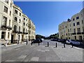
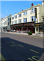
1
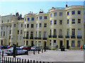
Brunswick Place
The western side between Western Road and Brunswick Square. Built between 1824-28 by Wilds and Busby originally as a separate estate from Brighton and administered as such an entity until 1875 when it became part of Hove.
Image: © Simon Carey
Taken: 3 Jun 2007
0.01 miles
2
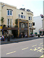
Freemasons, Western Road
Pub and restaurant with a distinct mosaic façade which still retains the name of the original brewery who owned it.
Image: © Simon Carey
Taken: 3 Jun 2007
0.01 miles
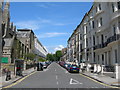
4
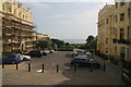
Hove: evening sunlight, Brunswick Place
Looking towards the sea from Western Road on a bright but cold and blustery April evening.
Image: © John Sutton
Taken: 7 Apr 2022
0.02 miles
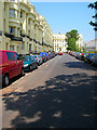
5
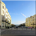
Brunswick Place in Hove
Part of the Brunswick Town area of Hove. The houses were built 1824–1830 in the Regency era.
Image: © Mat Fascione
Taken: 24 Jun 2024
0.02 miles
6
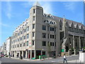
Western Road, Hove
At the corner of Cambridge Road. Showing Sheridan House, 112-116a Western Road, and St Patrick's Church.
Image: © Danny P Robinson
Taken: 31 May 2007
0.03 miles
7
Cambridge Road, Hove
Picture taken from Western Road.
Image: © Danny P Robinson
Taken: 31 May 2007
0.03 miles
8

Brunswick Square
The north western side as viewed from the junction with Brunswick Place. The square was built as a high class estate between 1824-28 by Wilds and Busby and originally administered as a separate entity until 1875 when it became part of Hove. The houses themselves eventually became subdivided into flats and bedsits and by 1945 had become so squalid and lacking in amenities that Hove council considered demolishing the entire estate. However, the outcry ensured a grade II listing was applied and the houses have returned to their original condition including the outside colour.
Image: © Simon Carey
Taken: 3 Jun 2007
0.03 miles
9
Brunswick Square
Another view of the north west corner this time looking north. Brunswick Place is to the right at the top.
Image: © Simon Carey
Taken: 3 Jun 2007
0.03 miles
10
Barneys, Western Road
Takes up the bulk of shop space between Farm Road (to the left) and Brunswick Place (out of picture to the right).
Image: © Simon Carey
Taken: 3 Jun 2007
0.04 miles