1
Melville Road
Residential street linking Julian Road with Dyke Road and developed from 1898 onwards.
Image: © Simon Carey
Taken: 15 Feb 2009
0.02 miles
2
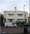
128-130, Dyke Road, Brighton
Two semi-detached houses dating from the 1850s. A plaque on number 128 to the right commemorates Magnus Volk, the inventor of the seafront railway that still bears his name. He lived here from 1914 until his death in 1937.
Image: © Simon Carey
Taken: 1 Nov 2015
0.02 miles
3
Pacific House, Dyke Road, Brighton
An office block completed in 1985 located just to the north of Seven Dials.
Image: © Simon Carey
Taken: 1 Nov 2015
0.03 miles
4
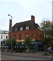
Good Companions pub
In Dyke Road near Seven Dials.
Website: http://www.goodcompanionsbrighton.co.uk/
Image: © Paul Gillett
Taken: 6 Apr 2012
0.03 miles
5
Dyke Road, BN1
Just north of Seven Dials.
Image: © Mike Quinn
Taken: 16 May 2012
0.03 miles
6
The Good Companions pub
The Good Companions pub, Seven Dials, Brighton
Image: © Nick Barber
Taken: 27 Oct 2018
0.03 miles
7
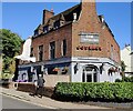
The Good Companions, Dyke Road, Brighton
Located on the corner of Russell Crescent and built by Tamplins brewery during a period expansion in the 1930s with an eye on the gentrification of public house culture in the city. Reputed to have officially opened on 3 September 1939, the day war broke out.
Image: © Simon Carey
Taken: 1 Nov 2015
0.03 miles
8
Dyke Road
The section that runs between Seven Dials and Old Shoreham Road is briefly the A2010. The road was the original northern route out of Brighton towards London prior to the development of Ditchling-Cuckfield route in the 18th century. The area was developed from the 1840s onwards and the road provides most of the local shopping facilities today.
Image: © Simon Carey
Taken: 26 Aug 2007
0.03 miles
9
Good Companion pub in Dyke Road
Near the Seven Dials in Brighton
Image: © Paul Gillett
Taken: 28 Jun 2011
0.04 miles
10
The Good Companions in Seven Dials, Brighton
A public house on the corner of Dyke Road and Russell Crescent, in the Seven Dials area of Brighton.
Image: © Mat Fascione
Taken: 24 Jun 2024
0.04 miles


