IMAGES TAKEN NEAR TO
Lower Market Street, HOVE, BN3 1AT
Introduction
This page details the photographs taken nearby to Lower Market Street, BN3 1AT by members of the Geograph project.
The Geograph project started in 2005 with the aim of publishing, organising and preserving representative images for every square kilometre of Great Britain, Ireland and the Isle of Man.

There are currently over 7.5m images from over14,400 individuals and you can help contribute to the project by visiting https://www.geograph.org.uk
Image Map
Images are licensed for reuse under creativecommons.org/licenses/by-sa/2.0
Notes
- Clicking on the map will re-center to the selected point.
- The higher the marker number, the further away the image location is from the centre of the postcode.
Image Listing (586 Images Found)
Images are licensed for reuse under creativecommons.org/licenses/by-sa/2.0
Image
Details
Distance
1
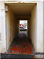
Covered Alley, Brunswick Street East
Linking Brunswick Street East to Lower Market Street and one of a number in the area.
Image: © Simon Carey
Taken: 25 Jan 2014
0.02 miles
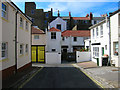
2
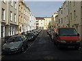
Lower Market Street
Running from Waterloo Street up the Old Market building, the street was erected at the end of the 1830s.
Image: © Simon Carey
Taken: 25 Jan 2014
0.02 miles
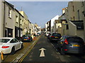
4
Brunswick Street East
Taken from Waterloo Street looking towards the 90 degree turn north. Opposite view to this Image
Image: © Simon Carey
Taken: 3 Aug 2007
0.03 miles
5
The Old Coach House, Brunswick Street East
Former stables now a residence in its own right. The rear of the buildings in Brunswick Terrace are behind. Brunswick Street East turns 90 degrees east at this point to join Waterloo Street.
Image: © Simon Carey
Taken: 3 Aug 2007
0.03 miles
6
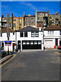
Brunswick Street East
The rear view of the big town houses in Brunswick Square contrasts with the small workshops in Brunswick Street East. Many of the original stables have been converted into small business premises or houses.The southern side of the Old Market is out of picture to the right whilst The Conqueror pub is out of picture to the left.
Image: © Simon Carey
Taken: 3 Aug 2007
0.03 miles
7
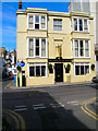
The Iron Duke, Waterloo Street
Built in 1825 as the Kerrison Arms Hotel acquiring its current name in 1974 followed by a number of variations on the theme until returning to the 1974 name in the late 1990s. Built as a separate development from Brunswick Square and initially quite isolated before the rest of the area urbanised.
Image: © Simon Carey
Taken: 3 Aug 2007
0.03 miles
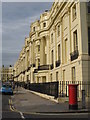
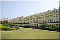
9
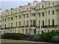
Brunswick Square, Hove
Upmarket apartments in a Georgian terrace overlooking the garden in the middle of the square.
Image: © Colin Smith
Taken: 31 Jul 2010
0.03 miles
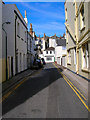
10
Brunswick Street East
Built as a service road for Brunswick Square behind which this street lies. Many of the old coach houses have been converted to dwellings with a few still used by car repair businesses. The houses on the right are the rear to those that front onto Lower Market Street.
Image: © Simon Carey
Taken: 25 Jan 2014
0.03 miles