IMAGES TAKEN NEAR TO
Nelson Row, BRIGHTON, BN2 9AH
Introduction
This page details the photographs taken nearby to Nelson Row, BN2 9AH by members of the Geograph project.
The Geograph project started in 2005 with the aim of publishing, organising and preserving representative images for every square kilometre of Great Britain, Ireland and the Isle of Man.

There are currently over 7.5m images from over14,400 individuals and you can help contribute to the project by visiting https://www.geograph.org.uk
Image Map
Images are licensed for reuse under creativecommons.org/licenses/by-sa/2.0
Notes
- Clicking on the map will re-center to the selected point.
- The higher the marker number, the further away the image location is from the centre of the postcode.
Image Listing (757 Images Found)
Images are licensed for reuse under creativecommons.org/licenses/by-sa/2.0
Image
Details
Distance
1
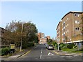
John Street, Brighton
The current road heads north from Edward Street and eventually ends on Albion Hill. However, it originally terminated at Carlton Hill with this section in view once known as Nelson Street until the old Victorian slum housing was cleared in the late 1930s though little was developed along the road until the 1960s. The road name appears to have changed in the 1970s. The building on the right is The Curve whilst in the distance is the former Lion & Unicorn pub that closed around 2010 and has now been converted into flats.
Image: © Simon Carey
Taken: 4 Oct 2015
0.02 miles
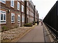
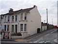
3
Nelson Row, Brighton
Flats built in 1930's
Image: © Paul Gillett
Taken: 11 Jun 2011
0.03 miles
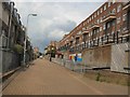
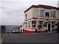
4
Lion and Unicorn, Sussex Street
Head south along John Street until the junction of Sussex Street is reached just north of the pub. Although rebuilt the pub remains in the same position it occupied before the slum clearances and is one of the few buildings in this area to retain its position. The steep gradient in this part of town is evident in Sussex Street.
Click on the link to take you to the next page. http://www.geograph.org.uk/photo/231626
Image: © Simon Carey
Taken: 1 Sep 2006
0.03 miles
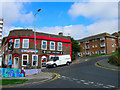
6
23, Queens Park Road, Brighton
How the other half lived. On the corner with Sussex Street. No blue plaque on the wall to tell the world my wife lived here until the age of three.
Image: © Bob Embleton
Taken: 9 Sep 2005
0.04 miles
7
Sussex Street, Brighton
Looking NW towards Brighton's main Railway Station. Taken from its junction with Windmill Street.
Image: © Bob Embleton
Taken: 9 Sep 2005
0.04 miles
8
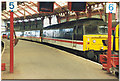
Train at Brighton Station
The Express from the North.
Image: © Ron Hann
Taken: Unknown
0.04 miles
9
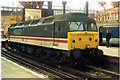
Diesel engine at Brighton Station
The engine off the Express.
Image: © Ron Hann
Taken: Unknown
0.04 miles
10
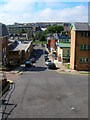
Morley Street
Head north along Nelson Row until Morley Street is reached then east up the stairs to Ashton Hill. Morley Street is the former western end of Sussex Street that was cleared in the 1930s. The slope of the street gives an idea of the steepness of some gradients in this part of town. The back of the Municipal Market is to the left and the southern part of Victoria Gardens is at the bottom of the street.
Click on the link to take you to the next page. http://www.geograph.org.uk/photo/231510
Image: © Simon Carey
Taken: 1 Sep 2006
0.04 miles