IMAGES TAKEN NEAR TO
Saltdean Vale, BRIGHTON, BN2 8HA
Introduction
This page details the photographs taken nearby to Saltdean Vale, BN2 8HA by members of the Geograph project.
The Geograph project started in 2005 with the aim of publishing, organising and preserving representative images for every square kilometre of Great Britain, Ireland and the Isle of Man.

There are currently over 7.5m images from over14,400 individuals and you can help contribute to the project by visiting https://www.geograph.org.uk
Image Map
Images are licensed for reuse under creativecommons.org/licenses/by-sa/2.0
Notes
- Clicking on the map will re-center to the selected point.
- The higher the marker number, the further away the image location is from the centre of the postcode.
Image Listing (58 Images Found)
Images are licensed for reuse under creativecommons.org/licenses/by-sa/2.0
Image
Details
Distance
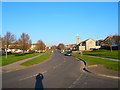
1
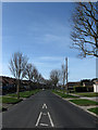
Saltdean Vale
Running across the floor of what was once a dry valley and has subsequenly become the main feeder road for the northern end of Saltdean and the A259.
Image: © Simon Carey
Taken: 15 Mar 2009
0.04 miles
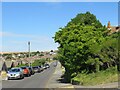
2
Greenbank Avenue, Saltdean
A residential road that runs from Chichester Drive East to Hempstead Road. It was laid out in the 1920s and originally called Quarry Avenue after the nearby pit which supplied the chalk that formed the surfaces of the early roads. Development was completed north of Mount Drive by the outbreak of World War Two with the southern section completed during the 1950s during which it acquired its current name.
Image: © Simon Carey
Taken: 28 Jan 2016
0.05 miles
3
Saltdean Vale
Taken from near to St. Nicholas Church
Image: © Paul Gillett
Taken: 28 Dec 2013
0.07 miles
4
Hawthorn Close
Small cul-de-sac off Saltdean Vale. The lovely morning has already got one occupant out washing his car.
Image: © Simon Carey
Taken: 15 Mar 2009
0.07 miles
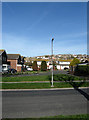
5
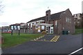
St Nicholas Church Hall, Saltdean
The Venue is also used for pre-school groups
Image: © Paul Gillett
Taken: 28 Dec 2013
0.08 miles
6
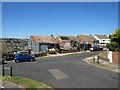
Rodmell Avenue, Saltdean
Rodmell Avenue is a residential road in Saltdean, on the Sussex coast near Brighton. This image is taken at the road's western end at its junction with Shepham Avenue, another residential road.
Image: © Malc McDonald
Taken: 24 Jul 2022
0.08 miles
7
St Nicholas' Church Hall, Saltdean Vale, Saltdean
Opened in 1951 and the main site of worship until neighbouring Image was consecrated in 1964.
Image: © Simon Carey
Taken: 28 Jan 2016
0.09 miles
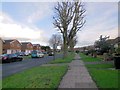
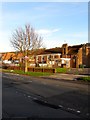
8
Glynde Avenue, Saltdean
A residential road that runs between Greenbank Avenue and Saltdean Vale that was developed in the 1950s. Some early morning frost still remains on the road and somebody has made use of the grit in the bunker on the left.
Image: © Simon Carey
Taken: 16 Jan 2016
0.09 miles
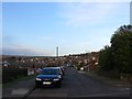
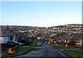
9
Saltdean Vale
The main road into northern Saltdean follows the old track that linked Saltdean Gap with Balsdean and eventually over the Downs towards Lewes. Prior to 1922 the whole area was open downland. The church on the right is St Nicholas'.
Image: © Simon Carey
Taken: 16 Dec 2007
0.10 miles
10
Greenbank Avenue, Saltdean
Greenbank Avenue is a residential road in Saltdean, on the Sussex coast near Brighton.
Image: © Malc McDonald
Taken: 24 Jul 2022
0.10 miles