IMAGES TAKEN NEAR TO
New Barn Road, BRIGHTON, BN2 7FN
Introduction
This page details the photographs taken nearby to New Barn Road, BN2 7FN by members of the Geograph project.
The Geograph project started in 2005 with the aim of publishing, organising and preserving representative images for every square kilometre of Great Britain, Ireland and the Isle of Man.

There are currently over 7.5m images from over14,400 individuals and you can help contribute to the project by visiting https://www.geograph.org.uk
Image Map
Images are licensed for reuse under creativecommons.org/licenses/by-sa/2.0
Notes
- Clicking on the map will re-center to the selected point.
- The higher the marker number, the further away the image location is from the centre of the postcode.
Image Listing (22 Images Found)
Images are licensed for reuse under creativecommons.org/licenses/by-sa/2.0
Image
Details
Distance
1
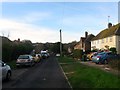
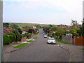
New Barn Road, Rottingdean
A cul de sac off Falmer Road built in the 1930s originally in Ovingdean parish but now deemed part of Rottingdean.
Image: © Simon Carey
Taken: 28 Dec 2015
0.02 miles
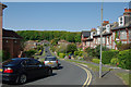
2
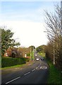
Falmer Road, Rottingdean
The B2123 heading northward through what was originally the parish of Ovingdean but is now regarded as the northern end of the village of Rottingdean.
Image: © Simon Carey
Taken: 28 Dec 2015
0.02 miles
4
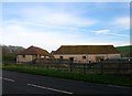
New Barn
An 18th century flint barn on the eastern side of Falmer Road.
Image: © Simon Carey
Taken: 28 Dec 2015
0.08 miles
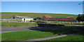
5
Court Ord Road, Rottingdean
Looking east towards its junction with Falmer Road (B2133). The square ends just beyond the ridge of the downs beyond.
Image: © Simon Carey
Taken: 16 Oct 2005
0.13 miles
6
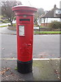
Rottingdean: postbox № BN2 218, Eley Drive
The asymmetry of the collection plate on this box is because it is a former airmail box, and would originally have had two collection plates side-by-side, of which only the left-hand one remains.
See Image for such a box in its original condition.
Image: © Chris Downer
Taken: 8 Nov 2015
0.13 miles
7
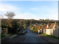
Court Ord Road, Rottingdean
The road heads west from Falmer Road providing the only access to a couple of estates to the north. Developed in the 1930s in the former parish of Ovingdean, the old parish boundary follows the southern side of the road, both road and estate are now considered part of Rottingdean. At the end of the road a footpath continues up the hill to the part of Ovingdean that was developed around the same time.
Image: © Simon Carey
Taken: 28 Dec 2015
0.15 miles
8
Cottages, Meadow Close
These substantially predate the other houses in Meadow Close, but don't seem to appear on the 1880 map.
Image: © Robin Webster
Taken: 19 May 2010
0.15 miles
9
Meadow Close
A residential road that loops round back on itself.
Image: © Robin Webster
Taken: 19 May 2010
0.18 miles
10
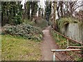
Footpath to Court Ord Road
from the Beacon Hill Nature Reserve
Image: © Paul Gillett
Taken: 3 Jan 2011
0.18 miles