IMAGES TAKEN NEAR TO
Tudor Close, Dean Court Road, BRIGHTON, BN2 7DF
Introduction
This page details the photographs taken nearby to Tudor Close, Dean Court Road, BN2 7DF by members of the Geograph project.
The Geograph project started in 2005 with the aim of publishing, organising and preserving representative images for every square kilometre of Great Britain, Ireland and the Isle of Man.

There are currently over 7.5m images from over14,400 individuals and you can help contribute to the project by visiting https://www.geograph.org.uk
Image Map
Images are licensed for reuse under creativecommons.org/licenses/by-sa/2.0
Notes
- Clicking on the map will re-center to the selected point.
- The higher the marker number, the further away the image location is from the centre of the postcode.
Image Listing (217 Images Found)
Images are licensed for reuse under creativecommons.org/licenses/by-sa/2.0
Image
Details
Distance
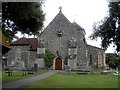
1
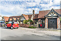
Tudor Close
Mock Tudor housing built in two parts, the first in 1924-8 designed by A Chaplin and incorporating parts from the former Manor Farm and the second in 1936-7 designed by R W H Jones. From an early stage the Tudor Close Hotel, it was converted to housing and flats in the 1950s. Grade II listed - see https://historicengland.org.uk/listing/the-list/list-entry/1380426?section=official-list-entry. For a close up of the doorway on the right, see Image
Image: © Ian Capper
Taken: 20 Sep 2022
0.01 miles
2
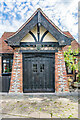
Doorway, Tudor Close
Doorway in Tudor Close, a mock Tudor housing built in two parts, the first in 1924-8 designed by A Chaplin and incorporating parts from the former Manor Farm and the second in 1936-7 designed by R W H Jones. From an early stage the Tudor Close Hotel, it was converted to housing and flats in the 1950s. Grade II listed - see https://historicengland.org.uk/listing/the-list/list-entry/1380426?section=official-list-entry. For a wider view see Image
Image: © Ian Capper
Taken: 20 Sep 2022
0.02 miles
3
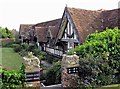
Tudor Close
Mock Tudor housing built in two parts, the first in 1924-8 designed by A Chaplin and incorporating parts from the former Manor Farm and the second in 1936-7 designed by R W H Jones. From an early stage the Tudor Close Hotel, it was converted to housing and flats in the 1950s. Grade II listed - see https://historicengland.org.uk/listing/the-list/list-entry/1380426?section=official-list-entry.
Image: © Ian Capper
Taken: 20 Sep 2022
0.02 miles
4
Tudor Close in Dean Court Road, Rottingdean
For details see: http://www.geograph.org.uk/photo/4808072 and http://www.mybrightonandhove.org.uk/page_id__8691_path__0p214p217p220p215p.aspx
Image: © Patrick Roper
Taken: 27 Apr 2007
0.02 miles
5
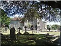
St Margaret's Church, Rottingdean
St Margaret's church is the parish church of Rottingdean in Brighton.
A place of worship has stood in the position since the Saxon period, although there is disagreement over whether any part of the current structure is of Saxon origin. The Normans started building a cruciform church in the early 12th century, More details at Wikipedia: http://en.wikipedia.org/wiki/St_Margaret's_Church,_Rottingdean
Church website: http://www.stmargaret.org.uk/
Image: © Paul Gillett
Taken: 23 Jun 2009
0.03 miles
6
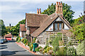
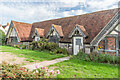
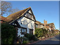
1 - 5 Dean Court Road
Mock Tudor terrace (even to the extent of having the year 1530 carved into the support beam of the gable of no 5, the nearest section). Referring to the date, the Sussex East Pevsner volume states "This could almost be believed, but the whole is the most entertaining fakery, using genuinely old materials and converted from farm buildings c.1930." On the left skyline in Rottingdean Windmill on Beacon Hill.
Image: © Ian Capper
Taken: 20 Sep 2022
0.04 miles
9
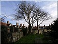
The north side of Rottingdean Churchyard
Image: © tristan forward
Taken: Unknown
0.04 miles
10
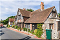
1 - 5 Dean Court Road
Mock Tudor terrace (even to the extent of having the year 1530 carved into the support beam of the gable of no 5, the nearest section). Referring to the date, the Sussex East Pevsner volume states "This could almost be believed, but the whole is the most entertaining fakery, using genuinely old materials and converted from farm buildings c.1930." On the left skyline in Rottingdean Windmill on Beacon Hill.
Image: © Ian Capper
Taken: 20 Sep 2022
0.04 miles