IMAGES TAKEN NEAR TO
Fairfield, HAILSHAM, BN27 4NE
Introduction
This page details the photographs taken nearby to Fairfield, BN27 4NE by members of the Geograph project.
The Geograph project started in 2005 with the aim of publishing, organising and preserving representative images for every square kilometre of Great Britain, Ireland and the Isle of Man.

There are currently over 7.5m images from over14,400 individuals and you can help contribute to the project by visiting https://www.geograph.org.uk
Image Map
Images are licensed for reuse under creativecommons.org/licenses/by-sa/2.0
Notes
- Clicking on the map will re-center to the selected point.
- The higher the marker number, the further away the image location is from the centre of the postcode.
Image Listing (37 Images Found)
Images are licensed for reuse under creativecommons.org/licenses/by-sa/2.0
Image
Details
Distance
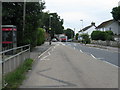
1
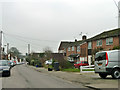
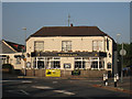
West End, Herstmonceux
Fairly central in the village that has developed by the A271, but perhaps the west end of the parish, as this is a good way from the church and castle.
Image: © Robin Webster
Taken: 13 Feb 2013
0.07 miles
7
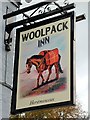
Woolpack Inn sign
See previous sign Image
Image: © Oast House Archive
Taken: 7 Sep 2019
0.11 miles
8
Eastern Promise, Gardner Street, Herstmonceux
Indian restaurant on the village's main shopping street. Herstmonceux is well served for small shops and businesses.
Image: © Simon Carey
Taken: 27 Jul 2008
0.11 miles
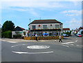
9
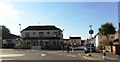
Mini roundabout at Herstmonceux
West End is the road that leads left.
Image: © Dave Spicer
Taken: 2 Jul 2013
0.11 miles
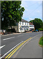
10
Woolpack Inn
Old coaching inn on the junction of the A271 and West End, a minor road to Cowbeech, in the centre of Herstmonceux village.
Image: © Simon Carey
Taken: 27 Jul 2008
0.11 miles