IMAGES TAKEN NEAR TO
Cinderford Lane, HAILSHAM, BN27 4HL
Introduction
This page details the photographs taken nearby to Cinderford Lane, BN27 4HL by members of the Geograph project.
The Geograph project started in 2005 with the aim of publishing, organising and preserving representative images for every square kilometre of Great Britain, Ireland and the Isle of Man.

There are currently over 7.5m images from over14,400 individuals and you can help contribute to the project by visiting https://www.geograph.org.uk
Image Map
Images are licensed for reuse under creativecommons.org/licenses/by-sa/2.0
Notes
- Clicking on the map will re-center to the selected point.
- The higher the marker number, the further away the image location is from the centre of the postcode.
Image Listing (9 Images Found)
Images are licensed for reuse under creativecommons.org/licenses/by-sa/2.0
Image
Details
Distance
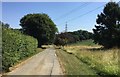
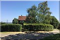
1
Cinderford Lane
The entrance to Old Barn Farm is on the left.
Image: © Robin Webster
Taken: 23 May 2013
0.02 miles
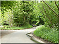
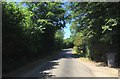
2
Corner on Cinderford Lane
At the corner a bridleway leaves on the left down the track to Blackford Farm, whilst a footpath crosses a stile up the bank straight ahead.
Image: © Chris Thomas-Atkin
Taken: 8 Jul 2018
0.05 miles
3
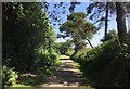
The Track to Blackford Farm
The tree lined track to Blackford Farm.
Image: © Chris Thomas-Atkin
Taken: 8 Jul 2018
0.07 miles
4
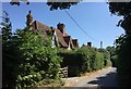
Cinderford Cottages
The cottages on Cinderford Lane.
Image: © Chris Thomas-Atkin
Taken: 8 Jul 2018
0.09 miles
5
Cinderford Lane
On Cinderford Lane close to the property of the same name.
Image: © Chris Thomas-Atkin
Taken: 8 Jul 2018
0.16 miles
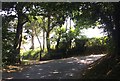
6
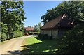
Barn beside Butler?s Wood
On the track heading towards Blackford Farm.
Image: © Chris Thomas-Atkin
Taken: 8 Jul 2018
0.19 miles
7
Bailiff?s Cottage
Bailiff’s Cottage near Blackford Farm.
Image: © Chris Thomas-Atkin
Taken: 8 Jul 2018
0.22 miles
8
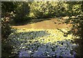
Pond in Jarvis?s Wood
Water lilies are a feature of this pond in Jarvis’s Wood.
Image: © Chris Thomas-Atkin
Taken: 8 Jul 2018
0.23 miles