IMAGES TAKEN NEAR TO
Deer Haven, Deanland Wood Park, HAILSHAM, BN27 3XZ
Introduction
This page details the photographs taken nearby to Deer Haven, Deanland Wood Park, BN27 3XZ by members of the Geograph project.
The Geograph project started in 2005 with the aim of publishing, organising and preserving representative images for every square kilometre of Great Britain, Ireland and the Isle of Man.

There are currently over 7.5m images from over14,400 individuals and you can help contribute to the project by visiting https://www.geograph.org.uk
Image Map
Images are licensed for reuse under creativecommons.org/licenses/by-sa/2.0
Notes
- Clicking on the map will re-center to the selected point.
- The higher the marker number, the further away the image location is from the centre of the postcode.
Image Listing (10 Images Found)
Images are licensed for reuse under creativecommons.org/licenses/by-sa/2.0
Image
Details
Distance
1
Pond by industrial units on Deanland Road
Image: © Dave Spicer
Taken: 24 Apr 2012
0.18 miles
2

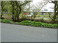
Deanland Villa
Twentieth century house on Deanland Road next to Deanland Wood.
Image: © Simon Carey
Taken: 30 May 2010
0.18 miles
4
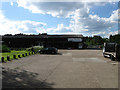
Mullany Business Park
Small business park located in what was once a depot opposite Deanland Wood.
Image: © Simon Carey
Taken: 30 May 2010
0.20 miles
5
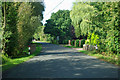
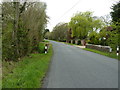
Bridge on Deanland Road
The road crosses a small tributary of the Cuckmere River.
Image: © Robin Webster
Taken: 11 Sep 2011
0.20 miles
6
Willow tree on Deanland Road
A feeder stream for the Cuckmere River flows under the bridge.
Image: © Dave Spicer
Taken: 24 Apr 2012
0.20 miles
7
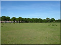
Sic Acres
The name of the field according to the 1837 tithe map which has been expanded to include three other fields; Hither Wood Field to the west, Kiln Field to the south west and Middle Lodge Field to the south. Deanland Wood Caravan Park lies beyond the trees at the end of the field.
Image: © Simon Carey
Taken: 22 May 2010
0.23 miles
8

Ten Acres
The name of the field according to the 1837 tithe map. Deanland Wood Caravan Park is beyond the far end of the field.
Image: © Simon Carey
Taken: 22 May 2010
0.23 miles
9
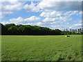
Coneyhurst
The name of the field according to the 1837 tithe map. To the left is Six Acre Wood which was marked as Coneyhurst Field in the same survey though it was marked as a wood with its current name on the 1875 OS map.
Image: © Simon Carey
Taken: 30 May 2010
0.24 miles
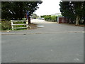
10
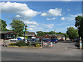
Deanland Wood Caravan Park
A view of the entrance from Deanland Road. The park's pub restaurant, The Inn on the Park, is open to the general public as well as residents. The caravan park seems to date from at least the 1960s.
Image: © Simon Carey
Taken: 30 May 2010
0.24 miles