IMAGES TAKEN NEAR TO
Sheepcote Lane, HAILSHAM, BN27 3SY
Introduction
This page details the photographs taken nearby to Sheepcote Lane, BN27 3SY by members of the Geograph project.
The Geograph project started in 2005 with the aim of publishing, organising and preserving representative images for every square kilometre of Great Britain, Ireland and the Isle of Man.

There are currently over 7.5m images from over14,400 individuals and you can help contribute to the project by visiting https://www.geograph.org.uk
Image Map
Images are licensed for reuse under creativecommons.org/licenses/by-sa/2.0
Notes
- Clicking on the map will re-center to the selected point.
- The higher the marker number, the further away the image location is from the centre of the postcode.
Image Listing (26 Images Found)
Images are licensed for reuse under creativecommons.org/licenses/by-sa/2.0
Image
Details
Distance
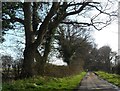
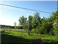
2
Mount Pleasant Farm
Old Wealden farmhouse next to Sheepcote Lane.
Image: © Simon Carey
Taken: 22 May 2010
0.03 miles
3
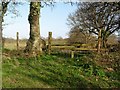
Drop fence, Mount Pleasant Farm, Chalvington
Image: © nick macneill
Taken: 15 Apr 2013
0.03 miles
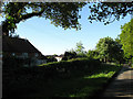
4
Mount Pleasant Farm
Framed by the hedgerow and viewed from the footpath that runs parallel to Sheepcote Lane. The building beyond the barns to the rear is Mount Pleasant Farm Cottage.
Image: © Simon Carey
Taken: 1 Jun 2011
0.03 miles
5
Vent Pipe, Mount Pleasant Farm
I'm assuming that is the case here, unless anyone else has any other ideas. It lies to the south of Mount Pleasant Farm.
Image: © Simon Carey
Taken: 22 May 2010
0.04 miles
6
Looking NE from path junction
Near Mount Pleasant Farm.
Image: © Dave Spicer
Taken: 7 May 2012
0.06 miles
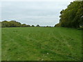
7
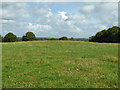
Mill Field (2)
The name of the field according to Selmeston's 1840 tithe map looking northwards towards the Weald. This former detached portion of Selmeston parish is now part of Chalvington.
Image: © Simon Carey
Taken: 1 Jun 2011
0.06 miles
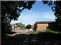
8
Sheepcote Lane passing Mount Pleasant Farm
Image: © Dave Spicer
Taken: 24 Apr 2012
0.07 miles
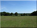
9
The mill mound in Mill Field
There is a distinct mound in this field, which is called Mill Field on the tithe map. The 1875 OS map shows no trace of a mill except a tree possibly on the spot. The mill must have gone a long time ago.
Image: © Robin Webster
Taken: 11 Sep 2011
0.08 miles
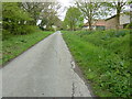
10
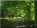
Sheepcote Lane
A section of the lane just south of Mount Pleasant Farm as it heads towards Selmeston Croft its final destination. A route of some antiquity believed to a be a track dating back to the Iron Age that linked the Downs with the pastures used for pannage in the Weald. The Romans later utilised this track to be the eastern end of their field system based around Ripe and Chalvington. Over the centuries it retained its use as a droving road and was an access route onto Dicker Common that lay to the north until enclosure in the mid 19th century. The lane is now only surfaced up to Selmeston Croft before becoming a byway to Poundfield Corner. To the north the lane's former crossing of Dicker Common is now just a bridleway.
Image: © Simon Carey
Taken: 22 May 2010
0.10 miles