IMAGES TAKEN NEAR TO
Chalvington Road, HAILSHAM, BN27 3SS
Introduction
This page details the photographs taken nearby to Chalvington Road, BN27 3SS by members of the Geograph project.
The Geograph project started in 2005 with the aim of publishing, organising and preserving representative images for every square kilometre of Great Britain, Ireland and the Isle of Man.

There are currently over 7.5m images from over14,400 individuals and you can help contribute to the project by visiting https://www.geograph.org.uk
Image Map
Images are licensed for reuse under creativecommons.org/licenses/by-sa/2.0
Notes
- Clicking on the map will re-center to the selected point.
- The higher the marker number, the further away the image location is from the centre of the postcode.
Image Listing (70 Images Found)
Images are licensed for reuse under creativecommons.org/licenses/by-sa/2.0
Image
Details
Distance
1
The Old Mill, Golden Cross
Built sometime in the early 19th century and known as either Wickens Mill or Dicker Mill. It remained operational until the eve of the First World War though only the roundhouse survives of the former post mill which has now been converted into a holiday home known as Jasmine Mill. See also Image for a similar view.
Image: © Simon Carey
Taken: 11 Feb 2012
0.00 miles
2
The Old Mill, Golden Cross
Built sometime in the early 19th century and known as either Wickens Mill or Dicker Mill. It remained operational until the eve of the First World War though only the roundhouse survives of the former post mill which has now been converted into a holiday home known as Jasmine Mill. See also Image for a similar view.
Image: © Simon Carey
Taken: 30 May 2006
0.00 miles
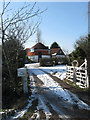
3
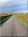
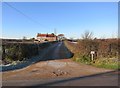
Chalvington Road
Another view of Image The straightness is due to it being laid out when the former Dicker Common was enclosed in 1813.
Image: © Simon Carey
Taken: 11 Feb 2012
0.01 miles
4
The Old Mill Holiday Park
Situated next to Image is a camping site for both touring and static caravans. See http://www.jasminewindmill.com/ for more details.
Image: © Simon Carey
Taken: 11 Feb 2012
0.03 miles
5
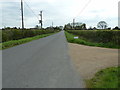
Chalvington Road
Looking towards Golden Cross. The round building to the left is this, Image whilst the big white building to the right is a caravan showroom. The straightness of the road indicates that it was made after the enclosure of the former common.
Image: © Simon Carey
Taken: 3 Mar 2007
0.03 miles
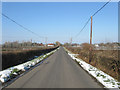
6
Chalvington Road southwards to Chalvington
Dicker Mill House on the right.
Image: © Dave Spicer
Taken: 24 Apr 2012
0.05 miles
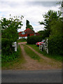
7
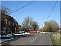
Rose Cottage, Golden Cross
Located on Chalvington Road which until the late 1970s ran along the course of the path to form a five way junction with Deanland Road, Burgh Hill Road and the A22. The junction was rejigged so that the former now runs into Chalvington Road which itself is now part of a staggered junction on the A22. Part of the old crossroads is now used as the car park for the Golden Cross Inn.
Image: © Simon Carey
Taken: 11 Feb 2012
0.06 miles
8
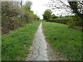
Bridleway C66
A very short path connecting Deanland Road with Chalvington Road.
Image: © Dave Spicer
Taken: 24 Apr 2012
0.07 miles
9
Dicker Mill House
Brick pattern in common in the area
Image: © The Saunterer
Taken: 2 Dec 2012
0.08 miles
10
Dicker Mill House, Golden Cross
Not marked on Yeakell & Gardner's 1778-83 map but is on the OS map of 1813 therefore built before the old Dicker Common was enclosed in the same year. The mill house for what was Wickens Mill whose remains can be found a little way up the road, see Image
Image: © Simon Carey
Taken: 11 Feb 2012
0.08 miles