IMAGES TAKEN NEAR TO
Forest Way, Deanland Wood Park, HAILSHAM, BN27 3SP
Introduction
This page details the photographs taken nearby to Forest Way, Deanland Wood Park, BN27 3SP by members of the Geograph project.
The Geograph project started in 2005 with the aim of publishing, organising and preserving representative images for every square kilometre of Great Britain, Ireland and the Isle of Man.

There are currently over 7.5m images from over14,400 individuals and you can help contribute to the project by visiting https://www.geograph.org.uk
Image Map
Images are licensed for reuse under creativecommons.org/licenses/by-sa/2.0
Notes
- Clicking on the map will re-center to the selected point.
- The higher the marker number, the further away the image location is from the centre of the postcode.
Image Listing (3 Images Found)
Images are licensed for reuse under creativecommons.org/licenses/by-sa/2.0
Image
Details
Distance
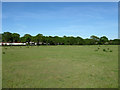
1

Ten Acres
The name of the field according to the 1837 tithe map. Deanland Wood Caravan Park is beyond the far end of the field.
Image: © Simon Carey
Taken: 22 May 2010
0.15 miles
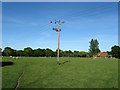
2
Sic Acres
The name of the field according to the 1837 tithe map which has been expanded to include three other fields; Hither Wood Field to the west, Kiln Field to the south west and Middle Lodge Field to the south. Deanland Wood Caravan Park lies beyond the trees at the end of the field.
Image: © Simon Carey
Taken: 22 May 2010
0.21 miles
3
Lower Barn Meadow
The name of the field according to the 1838 tithe map that has since been expanded to include House Field to the south. The house in view is Freshfields.
Image: © Simon Carey
Taken: 22 May 2010
0.25 miles