IMAGES TAKEN NEAR TO
Michelham Priory Road, HAILSHAM, BN27 3QP
Introduction
This page details the photographs taken nearby to Michelham Priory Road, BN27 3QP by members of the Geograph project.
The Geograph project started in 2005 with the aim of publishing, organising and preserving representative images for every square kilometre of Great Britain, Ireland and the Isle of Man.

There are currently over 7.5m images from over14,400 individuals and you can help contribute to the project by visiting https://www.geograph.org.uk
Image Map
Images are licensed for reuse under creativecommons.org/licenses/by-sa/2.0
Notes
- Clicking on the map will re-center to the selected point.
- The higher the marker number, the further away the image location is from the centre of the postcode.
Image Listing (97 Images Found)
Images are licensed for reuse under creativecommons.org/licenses/by-sa/2.0
Image
Details
Distance
1
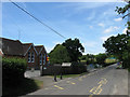
Park Mead Primary School
Opened in 1881 and named after the field it was built in. Michelham Priory Road is to the right heading towards Upper Dicker.
Image: © Simon Carey
Taken: 1 Jun 2011
0.01 miles
2
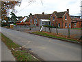
Park Mead Primary School
On Michelham Priory Road and marking the eastern extremity of the village of Upper Dicker.
Image: © Simon Carey
Taken: 17 Nov 2007
0.02 miles
3
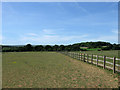
Park Mead
The name of the field according to Arlington's 1843 tithe map that was once part of Michelham Priory's deer park and I think it may well be owned by St Bede's and used as paddocks for their horses. Park Wood is in the distance to the right on the ridge.
Image: © Simon Carey
Taken: 1 Jun 2011
0.08 miles
4
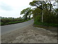
Michelham Priory Road entering Upper Dicker
Image: © Dave Spicer
Taken: 7 May 2012
0.08 miles
5
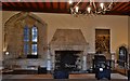
Michelham Augustinian Priory, founded 1229: The Prior's Chamber 3
Image: © Michael Garlick
Taken: 18 Nov 2016
0.11 miles
6
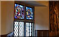
Michelham Augustinian Priory, founded 1229: The Prior's Chamber 2
Detail of the window
Image: © Michael Garlick
Taken: 18 Nov 2016
0.11 miles
7
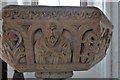
Michelham Priory: c12th Holy Water Stoup on c19th stand (detail 3)
Image: © Michael Garlick
Taken: 18 Nov 2016
0.11 miles
8
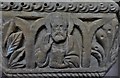
Michelham Priory: c12th Holy Water Stoup on c19th stand (detail 2)
Image: © Michael Garlick
Taken: 18 Nov 2016
0.11 miles
9
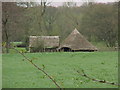
Iron Age Village
Iron Age Village at Michelham Priory.
Image: © Terry Jones
Taken: Unknown
0.11 miles
10
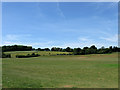
Playing Fields, St Bede's School
Unnamed in Arlington's 1843 tithe map the fields were once owned by Sir Horatio Bottomley as part of The Dicker Stud. They were sold off in 1938 and acquired by St Bede's in the 1980s and used for athletics, cricket and football. Beyond is Image part of which includes the schools five hole golf course. Park Wood is also to the left on the ridge.
Image: © Simon Carey
Taken: 1 Jun 2011
0.11 miles