IMAGES TAKEN NEAR TO
Upper Dicker, HAILSHAM, BN27 3QF
Introduction
This page details the photographs taken nearby to BN27 3QF by members of the Geograph project.
The Geograph project started in 2005 with the aim of publishing, organising and preserving representative images for every square kilometre of Great Britain, Ireland and the Isle of Man.

There are currently over 7.5m images from over14,400 individuals and you can help contribute to the project by visiting https://www.geograph.org.uk
Image Map
Images are licensed for reuse under creativecommons.org/licenses/by-sa/2.0
Notes
- Clicking on the map will re-center to the selected point.
- The higher the marker number, the further away the image location is from the centre of the postcode.
Image Listing (102 Images Found)
Images are licensed for reuse under creativecommons.org/licenses/by-sa/2.0
Image
Details
Distance
10
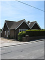
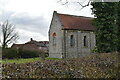
Henties, Coldharbour Road
Originally the village bakehouse from the 1860s which became a general stores until closure in 1980. The house is named after a couple who owned the latter. Now a private residence.
Image: © Simon Carey
Taken: 1 Jun 2011
0.03 miles