IMAGES TAKEN NEAR TO
Greenacres Drive, HAILSHAM, BN27 2PU
Introduction
This page details the photographs taken nearby to Greenacres Drive, BN27 2PU by members of the Geograph project.
The Geograph project started in 2005 with the aim of publishing, organising and preserving representative images for every square kilometre of Great Britain, Ireland and the Isle of Man.

There are currently over 7.5m images from over14,400 individuals and you can help contribute to the project by visiting https://www.geograph.org.uk
Image Map
Images are licensed for reuse under creativecommons.org/licenses/by-sa/2.0
Notes
- Clicking on the map will re-center to the selected point.
- The higher the marker number, the further away the image location is from the centre of the postcode.
Image Listing (111 Images Found)
Images are licensed for reuse under creativecommons.org/licenses/by-sa/2.0
Image
Details
Distance
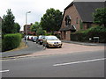
2

Marshfoot Lane
Taken from the junction of that lane with Vicarage Road and Vicarage Lane. The lane is the western end of an old drove road that crosses the Pevensey Levels from New Bridge.
Image: © Simon Carey
Taken: 11 Apr 2010
0.09 miles
3

Garrett Court, Hailsham
This new block of sheltered housing flats may not have been fully complete at the time of this spring 2007 view, although some of the top floor flats appear occupied.
Image: © Robin Webster
Taken: 8 Apr 2007
0.11 miles
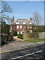
4
The Vicarage
The current vicarage is next door to Hailsham Grange the former vicarage and is located on the junction of Vicarage Road and Vicarage Lane.
Image: © Simon Carey
Taken: 15 Apr 2010
0.12 miles
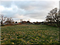
5

Large Marsh
The name of the field according to the 1844 tithe map. The field has lost its southern half to a recently constructed new school which lies beyond the fence to the right.
Image: © Simon Carey
Taken: 11 Apr 2010
0.12 miles
6
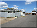
Hailsham Cattle Market
The last working cattle market in Sussex (The nearest east and west are Ashford and Salisbury respectively) has its origins in a charter issued by Henry III in 1252 which died out during the 17th century but was revived in 1786 and soon became the largest market in the county. Original located on the High Street it moved to this site in 1868 though how long it will remain here on what is now a prime piece of development land near the town centre is anyone's guess, a recent attempt by Aldi who purchased the freehold of the site was defeated when their plans were thrown out by the government during appeal.
Image: © Simon Carey
Taken: 11 Apr 2010
0.13 miles
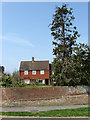
7
Hailsham Grange
Located on Vicarage Road and built in 1708 as the vicarage for neighbouring St Mary's. Now operating as a bed and breakfast with a small landscaped garden to the rear which is occasionally open to the public.
Image: © Simon Carey
Taken: 15 Apr 2010
0.13 miles
8
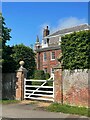
Hailsham Grange
Grade II* listed.
Image: © Oast House Archive
Taken: 3 Jun 2021
0.13 miles
9
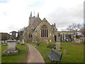
St Mary's Parish Church, Hailsham
Viewed from the South East
Image: © Paul Gillett
Taken: 18 Feb 2015
0.14 miles
10
Footway Piece (1)
The name of the field according to the 1844 tithe map. The last open field before reaching the outskirts of Hailsham.
Image: © Simon Carey
Taken: 11 Apr 2010
0.14 miles