IMAGES TAKEN NEAR TO
Geering Park, HAILSHAM, BN27 2LW
Introduction
This page details the photographs taken nearby to Geering Park, BN27 2LW by members of the Geograph project.
The Geograph project started in 2005 with the aim of publishing, organising and preserving representative images for every square kilometre of Great Britain, Ireland and the Isle of Man.

There are currently over 7.5m images from over14,400 individuals and you can help contribute to the project by visiting https://www.geograph.org.uk
Image Map
Images are licensed for reuse under creativecommons.org/licenses/by-sa/2.0
Notes
- Clicking on the map will re-center to the selected point.
- The higher the marker number, the further away the image location is from the centre of the postcode.
Image Listing (15 Images Found)
Images are licensed for reuse under creativecommons.org/licenses/by-sa/2.0
Image
Details
Distance
1
Mill Mini Market
A closed shop on Mill Road.
Image: © Simon Carey
Taken: 11 Apr 2010
0.10 miles
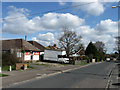
2

St Mary's Avenue
Residential road linking Mill Road with Marshfoot Lane. The estate which it serves was built in the 1960s and 70s.
Image: © Simon Carey
Taken: 11 Apr 2010
0.13 miles
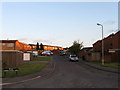
3

Greenwich Road
Part of a 1970s housing estate on the edge of Hailsham. Marshlands Primary School is in the distance.
Image: © Simon Carey
Taken: 3 May 2010
0.16 miles

5
Observatory View
Part of a 1970s housing estate on the edge of Hailsham. The name derives from the ability to see the dome of Herstmonceux Observatory across the flat expanse of the Pevensey Levels from Hailsham.
Image: © Simon Carey
Taken: 3 May 2010
0.19 miles
6

Howard Close
Small cul-de-sac off Swan Road built in the 1970s.
Image: © Simon Carey
Taken: 15 Apr 2010
0.20 miles
7

Bowley Road
Post-war housing estate on the south east edge of Hailsham. The road links Swan Road with The Stringmakers.
Image: © Simon Carey
Taken: 15 Apr 2010
0.20 miles
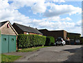
8

Halley Park
Part of a 1970s housing estate on the outskirts of Hailsham.
Image: © Simon Carey
Taken: 3 May 2010
0.20 miles
9

The Stringmakers
Post war estate on the south-east edge of Hailsham. The road links Archery Walk with Mill Road and commemorates the town's rope making business which sprang up in the late Victorian era.
Image: © Simon Carey
Taken: 15 Apr 2010
0.21 miles
10
Site of Hamlins Mill
This small works off Mill Road lies on the site of the last surviving windmill in Hailsham. The smock mill was constructed in 1834 and continued in operation until destroyed by a fire in 1923. The shell was reused as a power mill which remained working until another fire destroyed that in 1967. Nothing now remains of the mill though some of the former ancillary buildings are still in use.
Image: © Simon Carey
Taken: 3 May 2010
0.23 miles