IMAGES TAKEN NEAR TO
BN27 2FX
Introduction
This page details the photographs taken nearby to BN27 2FX by members of the Geograph project.
The Geograph project started in 2005 with the aim of publishing, organising and preserving representative images for every square kilometre of Great Britain, Ireland and the Isle of Man.

There are currently over 7.5m images from over14,400 individuals and you can help contribute to the project by visiting https://www.geograph.org.uk
Image Map
Images are licensed for reuse under creativecommons.org/licenses/by-sa/2.0
Notes
- Clicking on the map will re-center to the selected point.
- The higher the marker number, the further away the image location is from the centre of the postcode.
Image Listing (25 Images Found)
Images are licensed for reuse under creativecommons.org/licenses/by-sa/2.0
Image
Details
Distance
1
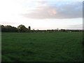
Seven Acres
The name of the field according to the 1844 tithe map. Beyond the hedge on the left is an estate of Hailsham.
Image: © Simon Carey
Taken: 3 May 2010
0.08 miles
2
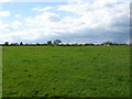
Great Barn Field
The name of the field according to the 1844 tithe map. The buildings in the distance are all on Marshfoot Lane.
Image: © Simon Carey
Taken: 3 May 2010
0.11 miles
3
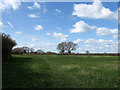
Little Barn Field
The name of the field according to the 1844 tithe map. Also contains the footpath that links Little Marshfoot Farm with Observatory View.
Image: © Simon Carey
Taken: 11 Apr 2010
0.14 miles
4
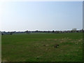
Denshire Field
The name of the field according to the 1844 tithe map. The outskirts of Hailsham can be seen to the right.
Image: © Simon Carey
Taken: 15 Apr 2010
0.15 miles
5
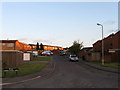
Observatory View
Part of a 1970s housing estate on the edge of Hailsham. The name derives from the ability to see the dome of Herstmonceux Observatory across the flat expanse of the Pevensey Levels from Hailsham.
Image: © Simon Carey
Taken: 3 May 2010
0.16 miles
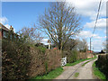
6
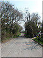
Marshfoot Lane
Where the surfaced public road ends and the farm track which is also a restricted byway begins.
Image: © Simon Carey
Taken: 15 Apr 2010
0.16 miles
8
Marshfoot Cattery
On Marshfoot Lane opposite Old Marshfoot Farm. The house next door is Haymeads.
Image: © Simon Carey
Taken: 15 Apr 2010
0.16 miles
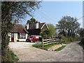
9
Little Marshfoot Farmhouse
Not certain if the farmhouse is part of the farm these days as there is a bungalow next to the barns in the distance. Part of the grounds of the farmhouse has been converted into a bed and breakfast.
Image: © Simon Carey
Taken: 11 Apr 2010
0.16 miles
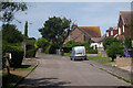
10

Halley Park
Part of a 1970s housing estate on the outskirts of Hailsham.
Image: © Simon Carey
Taken: 3 May 2010
0.16 miles