IMAGES TAKEN NEAR TO
Victoria Road, HAILSHAM, BN27 2AY
Introduction
This page details the photographs taken nearby to Victoria Road, BN27 2AY by members of the Geograph project.
The Geograph project started in 2005 with the aim of publishing, organising and preserving representative images for every square kilometre of Great Britain, Ireland and the Isle of Man.

There are currently over 7.5m images from over14,400 individuals and you can help contribute to the project by visiting https://www.geograph.org.uk
Image Map
Images are licensed for reuse under creativecommons.org/licenses/by-sa/2.0
Notes
- Clicking on the map will re-center to the selected point.
- The higher the marker number, the further away the image location is from the centre of the postcode.
Image Listing (192 Images Found)
Images are licensed for reuse under creativecommons.org/licenses/by-sa/2.0
Image
Details
Distance
1
Kingdom Hall of Jehovah's Witnesses, Victoria Road
Image: © Oast House Archive
Taken: 14 Jul 2021
0.01 miles
2
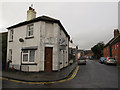
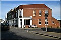
Former shop, Victoria Road
The property on the corner of Victoria Road and Garfield Road looks like it has been a shop, or maybe a pub.
Image: © Stephen Craven
Taken: 10 Nov 2012
0.02 miles
3
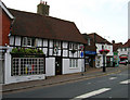
Fleur de Lys, Market Street, Hailsham
The building dates from around 1540 and was originally an inn. It has also been the town's poorhouse, a butchers, confectioners and numerous other shops. Today it is home to Hailsham Town Council.
Image: © Simon Carey
Taken: 27 Jul 2006
0.03 miles
4

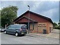
Hailsham fire station
Hailsham fire station, Victoria Road, Hailsham, East Sussex
Image: © Kevin Hale
Taken: 16 Jun 2007
0.04 miles
5
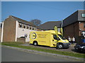
Battle Bus at ESAB HQ, Hailsham
The bus was purchased as the result of a legacy by The East Sussex Association of Blind and Partially Sighted People (ESAB) and will be used to take their services to outlying areas and to public events http://eastsussexblind.com/
The bus is standing outside the ESAB HQ in George Street, Hailsham
Image: © Paul Gillett
Taken: 9 Apr 2015
0.04 miles
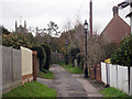
7

Stoney Lane
Narrow twitten that originally lead from Market Square to the common but now only goes as far as Garfield Road.
Image: © Simon Carey
Taken: 15 Apr 2010
0.05 miles
8
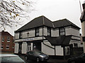
Hailsham Gospel Mission
The mission is on the corner of Station Road (foreground) and Garfield Road.
Image: © Stephen Craven
Taken: 10 Nov 2012
0.05 miles
9
Stoney Lane
A narrow road leading into a passageway between Elmsdown Place and High Street.
Image: © Oast House Archive
Taken: 11 Dec 2010
0.05 miles
10
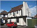
Railway Tavern, Hailsham
Pub on Station Road.
Image: © Oast House Archive
Taken: 19 Jul 2011
0.05 miles