IMAGES TAKEN NEAR TO
Rickney, HAILSHAM, BN27 1SD
Introduction
This page details the photographs taken nearby to BN27 1SD by members of the Geograph project.
The Geograph project started in 2005 with the aim of publishing, organising and preserving representative images for every square kilometre of Great Britain, Ireland and the Isle of Man.

There are currently over 7.5m images from over14,400 individuals and you can help contribute to the project by visiting https://www.geograph.org.uk
Image Map
Images are licensed for reuse under creativecommons.org/licenses/by-sa/2.0
Notes
- Clicking on the map will re-center to the selected point.
- The higher the marker number, the further away the image location is from the centre of the postcode.
Image Listing (28 Images Found)
Images are licensed for reuse under creativecommons.org/licenses/by-sa/2.0
Image
Details
Distance
1
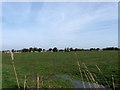
Churchlands Chilley Trade Piece
The name of the field according to the 1839 tithe map and part of Manxey Level. The churchlands indicate that at the time the farm and surrounding fields were owned by Chichester Cathedral. Trade is an old local word for a trackway across the marshes.
Image: © Simon Carey
Taken: 6 Apr 2010
0.05 miles
2
Chilley Stream Nr Pevensey East Sussex
Chilley Stream and Bridge on road from Pevensey to Chilley Green East Sussex
Image: © Janet Richardson
Taken: 22 Nov 2005
0.06 miles
3
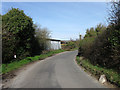
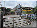
Churchlands Farm
The farm is relatively recent as it does not appear on the 1927 map though some outbuildings exist by 1951. Two anti-tank cylinders are visible on the right hand side of the road that would have formed a roadblock at this point during the Second World War.
Image: © Simon Carey
Taken: 6 Apr 2010
0.06 miles
4
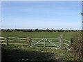
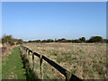
Banky Piece
The name of the field according to the 1839 tithe map and part of Manxey Level.
Image: © Simon Carey
Taken: 6 Apr 2010
0.07 miles
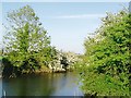
6
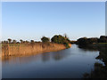
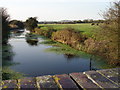
Pevensey Haven
Looking down the waterway constructed in the 12th-13th century when this part of the former marsh was inned and reclaimed. It is the major drain for the water in the western part of the Pevensey Levels.
Image: © Simon Carey
Taken: 17 Jan 2010
0.12 miles
7
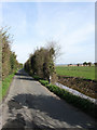
Rickney Lane
Single track lane that runs across the marsh from Pevensey to Hailsham via Rickney and Downash.
Image: © Simon Carey
Taken: 6 Apr 2010
0.12 miles
8
Great Haven Piece
The name of the field according to the 1839 tithe map with Martin's Ditch the waterway on the foreground.
Image: © Simon Carey
Taken: 17 Jan 2010
0.13 miles
9
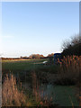
Great King's Salts
The name of the field according to the 1838 tithe map and part of Hankham Level. One of a number of fields in the vicinity which share this name. The land on the right is now a paddock with the bushes beyond marking the course of Pevensey Haven.
Image: © Simon Carey
Taken: 17 Apr 2010
0.14 miles
10
Pevensey Haven in May, East Sussex
The 'Haven' is one of the main drains for Pevensey Levels.
Image: © nick macneill
Taken: 25 May 2006
0.15 miles