IMAGES TAKEN NEAR TO
Boreham Lane, HAILSHAM, BN27 1RS
Introduction
This page details the photographs taken nearby to Boreham Lane, BN27 1RS by members of the Geograph project.
The Geograph project started in 2005 with the aim of publishing, organising and preserving representative images for every square kilometre of Great Britain, Ireland and the Isle of Man.

There are currently over 7.5m images from over14,400 individuals and you can help contribute to the project by visiting https://www.geograph.org.uk
Image Map
Images are licensed for reuse under creativecommons.org/licenses/by-sa/2.0
Notes
- Clicking on the map will re-center to the selected point.
- The higher the marker number, the further away the image location is from the centre of the postcode.
Image Listing (23 Images Found)
Images are licensed for reuse under creativecommons.org/licenses/by-sa/2.0
Image
Details
Distance
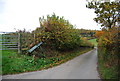
1
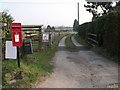
Entrance to Old Barn Farm south of Boreham Street
Image: © nick macneill
Taken: 25 Mar 2011
0.08 miles
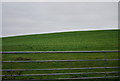
8
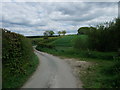
Jenners Lane
Narrow country lane linking Boreham Lane with Wood Lane, its course marked by the line of hedges. Wartling Wood is in the background.
Image: © Simon Carey
Taken: 29 Mar 2008
0.15 miles
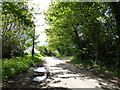
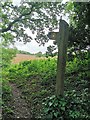
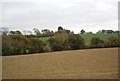
9
Unnamed lane near Boreham Street
The 1066 Country Walk from Herstmonceux (right) makes brief use of the lane before following the finger post (at bend in road) towards Boreham Street (left)
Image: © Tim Heaton
Taken: 16 May 2012
0.15 miles
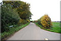
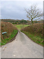
10
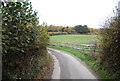
Jenners Lane
A single track narrow lane.
Image: © N Chadwick
Taken: 4 Nov 2010
0.16 miles