IMAGES TAKEN NEAR TO
Church Road, HAILSHAM, BN27 1RJ
Introduction
This page details the photographs taken nearby to Church Road, BN27 1RJ by members of the Geograph project.
The Geograph project started in 2005 with the aim of publishing, organising and preserving representative images for every square kilometre of Great Britain, Ireland and the Isle of Man.

There are currently over 7.5m images from over14,400 individuals and you can help contribute to the project by visiting https://www.geograph.org.uk
Image Map
Images are licensed for reuse under creativecommons.org/licenses/by-sa/2.0
Notes
- Clicking on the map will re-center to the selected point.
- The higher the marker number, the further away the image location is from the centre of the postcode.
Image Listing (11 Images Found)
Images are licensed for reuse under creativecommons.org/licenses/by-sa/2.0
Image
Details
Distance
1
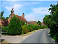
Church Road, Flowers Green
Small hamlet in the parish Herstmonceux on the road from the village to the parish church. The first house on the left is Pernes an 18th century listed building.
Image: © Simon Carey
Taken: 27 Jul 2008
0.08 miles
2
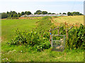
Footbridge and Glasshouses
Taking the footpath past Flowers green Nursery to Flowers Green.
Image: © Simon Carey
Taken: 27 Jul 2008
0.09 miles
3
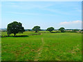
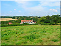
Field Boundaries
Oaks and small hedges marking the borders of fields between Flowers Green and Butlers Lane.
Image: © Simon Carey
Taken: 27 Jul 2008
0.11 miles
5
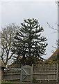
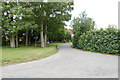
Monkey Puzzle Tree, Church Road, Herstmonceux
Image: © J.Hannan-Briggs
Taken: 29 Mar 2013
0.15 miles
6
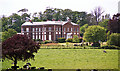
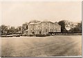
Herstmonceux Place, Herstmonceux
An elegant work of 1777, the bows crowned by shallow saucer domes a favoured motif of the architect, Samuel Wyatt. Between the windows are Coade stone reliefs. Wyatt also remodelled the right-hand facade, previously 1720s. This later work was for the Reverand Robert Hare. The church must have paid well. Grade I listed.
The house is now flats. This photo shows that the house was originally stuccoed: Image
The date of the photo is uncertain.
Image: © Stephen Richards
Taken: Unknown
0.23 miles
7
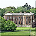
Herstmonceux Place
This is a cross-grid shot. The camera was in TQ6410.
Image: © Ian Hawfinch
Taken: 27 May 2021
0.23 miles
8
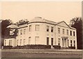
Herstmonceux Place
Herstmonceux Place in the 19th century. It is now divided into flats.
The north front of the house (not visible in this photo) was built in the late 17th century. The south and east fronts (seen here) were designed by Samuel Wyatt in 1778. The stucco rendering was removed about 1900.
Image: © unknown - 19th century photograph in my posession
Taken: Unknown
0.23 miles
9
Butlers Farm
Weatherboarded Wealden farmhouse on Butlers Lane.
Image: © Simon Carey
Taken: 27 Jul 2008
0.23 miles
10
Herstmonceux Place
This picture shows Herstmonceux Place, circa 1932, after which it ceased to be a private house and was divided into flats.
The north front of the house (not visible in this photo) was built in the late 17th century. The south and east fronts (seen here) were designed by Samuel Wyatt in 1778. The white panels are made of Coade Stone http://en.wikipedia.org/wiki/Coade_stone
Image: © Miss Helen Mary James (deceased)
Taken: Unknown
0.23 miles