IMAGES TAKEN NEAR TO
Selmeston, POLEGATE, BN26 6UG
Introduction
This page details the photographs taken nearby to BN26 6UG by members of the Geograph project.
The Geograph project started in 2005 with the aim of publishing, organising and preserving representative images for every square kilometre of Great Britain, Ireland and the Isle of Man.

There are currently over 7.5m images from over14,400 individuals and you can help contribute to the project by visiting https://www.geograph.org.uk
Image Map
Images are licensed for reuse under creativecommons.org/licenses/by-sa/2.0
Notes
- Clicking on the map will re-center to the selected point.
- The higher the marker number, the further away the image location is from the centre of the postcode.
Image Listing (45 Images Found)
Images are licensed for reuse under creativecommons.org/licenses/by-sa/2.0
Image
Details
Distance
1
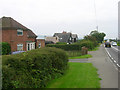
Police House, Lewes Road, Selmeston
The nearest house is the former village police station which probably closed in the 1960s/70s. The dwellings beyond are Council Cottages both on the busy A27 heading out the village.
Image: © Simon Carey
Taken: 29 Aug 2008
0.01 miles
2
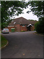
Selmeston Village Hall
Viewed from The Street the hall is at the southern end of the recreation ground.
Image: © Simon Carey
Taken: 29 Aug 2008
0.06 miles
3
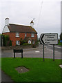
Corner Cottage, Selmeston
At the junction of The Street and Lewes Road, the A27. The cottage dates from the 19th century.
Image: © Simon Carey
Taken: 29 Aug 2008
0.06 miles
4
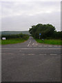
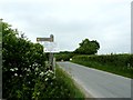
Bo Peep Lane
Taken from the crossroads formed by Lewes Road, the A27 and Common Lane from which the picture is taken from. The lane uses an old Roman terraceway to climb the north escarpment of the South Downs.
Image: © Simon Carey
Taken: 29 Aug 2008
0.07 miles
5
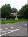
War Memorial, Selmeston
At the junction of The Street and Lewes Road, the A27. The other side of The Street is Image from which this image has been taken.
Image: © Simon Carey
Taken: 29 Aug 2008
0.08 miles
6
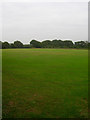
Recreation Ground, Selmeston
Also the cricket ground for the local village team.
Image: © Simon Carey
Taken: 29 Aug 2008
0.08 miles
7
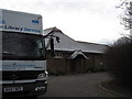
Selmeston Village Hall
The village hall with the Mobile Library parked awaiting customers.
Image: © Terry Head
Taken: 5 Jan 2010
0.08 miles
8
Road closed to Bo Peep car park on the South Downs Way
Unfortunately this meant a detour to the southern end of my walk to find a parking spot. This reason for the closure was a downhill long board skating event.
Image: © Dave Spicer
Taken: 2 Jun 2012
0.08 miles
9
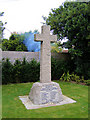
Great War Memorial, Selmeston
Situated near the Barley Mow pub on the A27 at Selmeston, this granite memorial commemorates the fallen from the parishes of Selmeston and nearby Alciston.
Image: © Kevin Gordon
Taken: 14 Oct 2008
0.08 miles
10
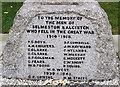
Names from the Great War Memorial, Selmeston
Names include 19 year old Arthur Chilvers of Manor Villa, Selmeston; Sid Coleman and David Gumbrill of the Royal Sussex Regiment; 32 year old James Hayward of Alciston; Charles Hylands of Old Town Cottage, Selmeston; Charles Short of Firle and Private W R West of Chalvington. 39 year old Charles Gowers died on board HMS Hunter in April 1940 and 19 year old Hugh Stacey of Alciston. He was in the Royal Armoured Corps and the recipient of the Bronze Star from the US Army.
Image: © Kevin Gordon
Taken: 14 Oct 2008
0.08 miles