IMAGES TAKEN NEAR TO
Selmeston, POLEGATE, BN26 6UB
Introduction
This page details the photographs taken nearby to BN26 6UB by members of the Geograph project.
The Geograph project started in 2005 with the aim of publishing, organising and preserving representative images for every square kilometre of Great Britain, Ireland and the Isle of Man.

There are currently over 7.5m images from over14,400 individuals and you can help contribute to the project by visiting https://www.geograph.org.uk
Image Map
Images are licensed for reuse under creativecommons.org/licenses/by-sa/2.0
Notes
- Clicking on the map will re-center to the selected point.
- The higher the marker number, the further away the image location is from the centre of the postcode.
Image Listing (14 Images Found)
Images are licensed for reuse under creativecommons.org/licenses/by-sa/2.0
Image
Details
Distance
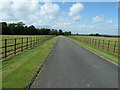
2
Barn Field
The name of the field according to the 1840 tithe map with the walls belonging to Sherrington Manor at the southern end of the field.
Image: © Simon Carey
Taken: 8 Aug 2010
0.12 miles
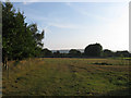
3
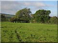
Moat Field
The name of the field according to the 1840 tithe map which has been enlarged to include Brick Field to the north behind the photographer. The moat once belonged to Sherrington Manor which lies beyond the trees to the right. Bostal Hill provides the backdrop.
Image: © Simon Carey
Taken: 8 Aug 2010
0.13 miles
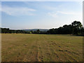
4
Barley Field
The name of the field according to the 1840 tithe map. The wooden fence in the distance marks the course of the drive to Sherrington Manor whilst Bostal Hill can be seen in the background.
Image: © Simon Carey
Taken: 8 Aug 2010
0.13 miles
5
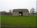
Barn, Sherrington Manor
Just south of the railway line.
Image: © Simon Carey
Taken: 15 Apr 2006
0.13 miles
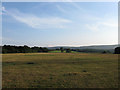
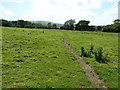
7
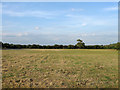
Piccastes
The name of the field according to the 1840 tithe map viewed from the footpath that links Selmeston with Langtye Lane.
Image: © Simon Carey
Taken: 8 Aug 2010
0.19 miles
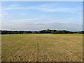
8
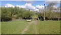
Footpath from Selmeston
The footpath continues across the A22 towards Charleston Farmhouse.
Image: © Oast House Archive
Taken: 16 Oct 2010
0.19 miles
10
Brick Field (1)
The name of the field according to the 1840 tithe map. The field was split in two by the railway in 1846 with the southern portion of the field amalgamated with Moat Field, the former boundary just visible on the ground by a small hump that runs across the foreground.
Image: © Simon Carey
Taken: 8 Aug 2010
0.20 miles