IMAGES TAKEN NEAR TO
Tye Hill Lane, POLEGATE, BN26 6SF
Introduction
This page details the photographs taken nearby to Tye Hill Lane, BN26 6SF by members of the Geograph project.
The Geograph project started in 2005 with the aim of publishing, organising and preserving representative images for every square kilometre of Great Britain, Ireland and the Isle of Man.

There are currently over 7.5m images from over14,400 individuals and you can help contribute to the project by visiting https://www.geograph.org.uk
Image Map
Images are licensed for reuse under creativecommons.org/licenses/by-sa/2.0
Notes
- Clicking on the map will re-center to the selected point.
- The higher the marker number, the further away the image location is from the centre of the postcode.
Image Listing (122 Images Found)
Images are licensed for reuse under creativecommons.org/licenses/by-sa/2.0
Image
Details
Distance
1
Crowbore
Name of the house viewed from the Weald Way across a field north of Arlington.
Image: © Simon Carey
Taken: 3 Jul 2009
0.01 miles
2
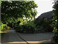
Woodhorne Manor
The former rectory with parts dating back to the 14th century, the old building is mostly obscured by the new extension in view.
Image: © Simon Carey
Taken: 3 Jun 2011
0.05 miles
3
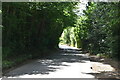
Tye Hill Lane
Narrow minor lane that links the centre of Arlington village with Tye Hill Road.
Image: © Simon Carey
Taken: 3 Jun 2011
0.06 miles
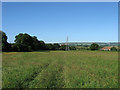
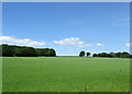
5
Butt Field (2)
Two days on from Image and the grass has been cut and collected. The footpath heads north to Raylands Farm.
Image: © Simon Carey
Taken: 3 Jun 2011
0.09 miles
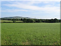
6
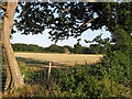
Butt Field (1)
The name of the field according to Arlington's 1843 tithe map. St Pancras church is beyond the electricity pylon whilst Church Barn is to the right. The South Downs provides the backdrop with Bo-Peep chalk pit visible on the right. The name could mean an area once used for archery practice or an area of the field where soil was deposited once the plough was turned. See Image for a view from the opposite end of the field.
Image: © Simon Carey
Taken: 1 Jun 2011
0.09 miles
7
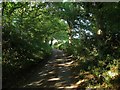
The Knowle/Street Field
Another view of Image from Tye Hill Lane with Wilmington Hill and Windover Hill providing the backdrop.
Image: © Simon Carey
Taken: 3 Jun 2011
0.09 miles
8
Street Field/The Knowle
The name of the field according to Arlington's 1843 tithe map with Street Field in the foreground and The Knowle further up the slope. Yeakell & Gardner's map of 1778-83 has a lane bisecting the two linking the sharp bend of the current road with Tye Hill Lane beyond the trees to the left. This route had gone by the time of the first OS map of 1813.
Image: © Simon Carey
Taken: 1 Jun 2011
0.10 miles
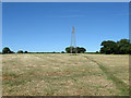
9
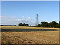
Electricity Pylon near Arlington
Viewed from the Weald Way north of St Pancras' church. Another footpath heads to the north of the field on its way to Raylands Farm.
Image: © Simon Carey
Taken: 3 Jul 2009
0.11 miles