IMAGES TAKEN NEAR TO
Bayleys Lane, POLEGATE, BN26 6RT
Introduction
This page details the photographs taken nearby to Bayleys Lane, BN26 6RT by members of the Geograph project.
The Geograph project started in 2005 with the aim of publishing, organising and preserving representative images for every square kilometre of Great Britain, Ireland and the Isle of Man.

There are currently over 7.5m images from over14,400 individuals and you can help contribute to the project by visiting https://www.geograph.org.uk
Image Map
Images are licensed for reuse under creativecommons.org/licenses/by-sa/2.0
Notes
- Clicking on the map will re-center to the selected point.
- The higher the marker number, the further away the image location is from the centre of the postcode.
Image Listing (41 Images Found)
Images are licensed for reuse under creativecommons.org/licenses/by-sa/2.0
Image
Details
Distance
1
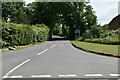
Bayley's Lane
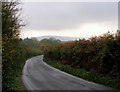
Minor road connecting Placket Corner to the old crossroads at Thornwell. Underwood Farm is on the left.
Image: © Simon Carey
Taken: 11 Jun 2011
0.02 miles
2
Barley's Land
The name of the field according to Wilmington's 1838 tithe map viewed from Bayley's Lane. Much of the field lies to the rear of Underwood Farm to the east. Placket Coppice is the wood.
Image: © Simon Carey
Taken: 11 Jun 2011
0.05 miles
3
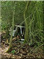
Rusting Away
Either an old Trabant or Renault rusting away behind Windlebrook. Viewed from the footpath that links Hayreed Lane to Bayley's Lane.
Image: © Simon Carey
Taken: 11 Jun 2011
0.09 miles
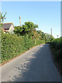
4
Field near Underwood Farm
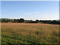
Unnamed on Wilmington's 1838 tithe survey along with a number of others in the vicinity. Viewed from Bayley's Lane with the late evening sun giving the grassland colour.
Image: © Simon Carey
Taken: 26 Jun 2011
0.10 miles
5
Through the Gate or Jump?
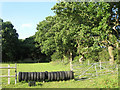
The latter for those energetic walkers. For the record I jumped. On the footpath that links Hayreed Lane with Bayley's Lane.
Image: © Simon Carey
Taken: 11 Jun 2011
0.11 miles
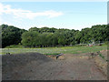
6
Site of Arlington Concrete Blocks Works
Marked as a brickyard in Arlington's 1843 tithe survey and as an old brick kiln on the 1874 OS map after which it seems to have fallen out of use until the 1950s when it extended into a neighbouring field and became Arlington Concrete Blocks Works which closed about five years ago. Since 2008 there has been planning permission to build six homes on the site which has yet to be taken up.
Image: © Simon Carey
Taken: 26 Jun 2011
0.13 miles
7

Postponed building project near Arlington Tea Gardens
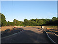
Although there were high barriers, the lens found a small gap.
Image: © Dave Spicer
Taken: 9 Jul 2012
0.14 miles
8
Bayley's Lane, Arlington
Looking south towards Wilmington with the South Downs in the distance
Image: © Kevin Gordon
Taken: 4 Nov 2008
0.14 miles
9
Ox Hide (1)
The name of the field according to Wilmington's 1838 tithe map and one of three in the immediate vicinity of the same name. Abbot's Wood lies at the end of this section of the field which has been turned iunto a number of paddocks. See also Image, Image and Image
Image: © Simon Carey
Taken: 11 Jun 2011
0.14 miles