IMAGES TAKEN NEAR TO
Kings Ride, POLEGATE, BN26 5XN
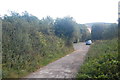
Introduction
This page details the photographs taken nearby to Kings Ride, BN26 5XN by members of the Geograph project.
The Geograph project started in 2005 with the aim of publishing, organising and preserving representative images for every square kilometre of Great Britain, Ireland and the Isle of Man.

There are currently over 7.5m images from over14,400 individuals and you can help contribute to the project by visiting https://www.geograph.org.uk
Image Map
Images are licensed for reuse under creativecommons.org/licenses/by-sa/2.0
Notes
- Clicking on the map will re-center to the selected point.
- The higher the marker number, the further away the image location is from the centre of the postcode.
Image Listing (36 Images Found)
Images are licensed for reuse under creativecommons.org/licenses/by-sa/2.0
Image
Details
Distance
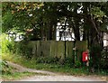
1
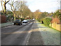
Deans Road
Taken from a position just west of The Furlongs
Image: © Terry Head
Taken: 5 Jan 2010
0.08 miles
2
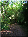
Bridleway Junction near Alfriston
The bridleway running south to north links the South Downs Way with North Road whilst that heading east goes into the residential part of Alfriston village.
Image: © Simon Carey
Taken: 13 Sep 2008
0.08 miles
3
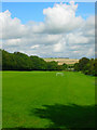
Private Field
Bounded by a bridleway to the left and the rear of the houses in The Broadway to the right. The equipment suggests somebody in that road may well own this field. Taken from the bridleway that provides the southern boundary.
Image: © Simon Carey
Taken: 13 Sep 2008
0.13 miles
4
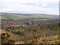
Alfriston
Looking south east from the bridleway that links the Sanctuary to Long Burgh.
Image: © Simon Carey
Taken: 17 Feb 2006
0.15 miles
6
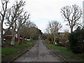
The Broadway
A residential road linking Kings Ride to North Road. The course of the road existed as a track towards the end of the 19th century though development did not really commence until the 1960s. The junction with Deans Road is just visible in the distance.
Image: © Simon Carey
Taken: 27 Jan 2013
0.16 miles
7
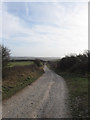
South Downs Way
This section runs southwards from Long Burgh before heading into the village of Alfriston.
Image: © Simon Carey
Taken: 27 Jan 2013
0.16 miles
8
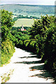
Looking towards Alfriston from the South Downs Way path
The long walk up from Alfriston to Firle Beacon
Image: © Nigel Freeman
Taken: Unknown
0.16 miles
9
The South Downs Way leaving Alfriston
Image: © Trevor Harris
Taken: 26 Aug 2012
0.17 miles
10
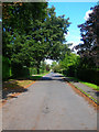
The Broadway
Runs from Kings Ride to North Road and is the residential part of the village. Taken from the junction with Deans Road.
Image: © Simon Carey
Taken: 13 Sep 2008
0.17 miles