IMAGES TAKEN NEAR TO
Weavers Lane, POLEGATE, BN26 5TH
Introduction
This page details the photographs taken nearby to Weavers Lane, BN26 5TH by members of the Geograph project.
The Geograph project started in 2005 with the aim of publishing, organising and preserving representative images for every square kilometre of Great Britain, Ireland and the Isle of Man.

There are currently over 7.5m images from over14,400 individuals and you can help contribute to the project by visiting https://www.geograph.org.uk
Image Map
Images are licensed for reuse under creativecommons.org/licenses/by-sa/2.0
Notes
- Clicking on the map will re-center to the selected point.
- The higher the marker number, the further away the image location is from the centre of the postcode.
Image Listing (580 Images Found)
Images are licensed for reuse under creativecommons.org/licenses/by-sa/2.0
Image
Details
Distance
1
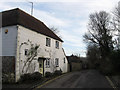
![Alfriston houses [3]](https://s2.geograph.org.uk/geophotos/07/23/08/7230830_deb9546e_120x120.jpg)
Alfriston houses [3]
Partly hidden behind scaffolding, Sevencrofts, Weavers Lane, was built in the 18th century. Constructed of flint and stuccoed brick under a hipped tile roof. Listed, grade II, with details at: https://historicengland.org.uk/listing/the-list/list-entry/1287071
Alfriston is a village in East Sussex, some 6½ miles northwest of Eastbourne and 3½ miles northeast of Seaford. The village lies on the west bank of the Cuckmere River. There is evidence of occupation in the Neolithic period, with several long barrows on the surrounding downs. The village is home to The Star Inn, built in 1345 to accommodate monks and pilgrims en route from Battle Abbey to Chichester Cathedral. Also in the village is the Old Clergy House, the first building acquired by the National Trust in 1898.
Image: © Michael Dibb
Taken: 6 May 2022
0.00 miles
2
Sevencrofts, Weavers Lane
The house dates from the 18th century and lies opposite Image
Image: © Simon Carey
Taken: 27 Jan 2013
0.01 miles
3
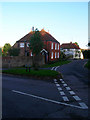
Weavers Lane
Linking this crossroads with High Street. Taken from the junction with Star Lane.
Image: © Simon Carey
Taken: 24 Aug 2008
0.01 miles
4
![Alfriston houses [4]](https://s1.geograph.org.uk/geophotos/07/23/08/7230837_181d5933_120x120.jpg)
Alfriston houses [4]
Saffrons House, Weavers Lane, was built in the early 19th century. Constructed of brick, tile-hung under a hipped tile roof. Listed, grade II, with details at: https://historicengland.org.uk/listing/the-list/list-entry/1043355
Alfriston is a village in East Sussex, some 6½ miles northwest of Eastbourne and 3½ miles northeast of Seaford. The village lies on the west bank of the Cuckmere River. There is evidence of occupation in the Neolithic period, with several long barrows on the surrounding downs. The village is home to The Star Inn, built in 1345 to accommodate monks and pilgrims en route from Battle Abbey to Chichester Cathedral. Also in the village is the Old Clergy House, the first building acquired by the National Trust in 1898.
Image: © Michael Dibb
Taken: 6 May 2022
0.01 miles
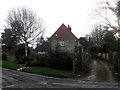
5
Cottage in Star Lane, Alfriston
With a nice 'cat-slide' roof.
Image: © Kevin Gordon
Taken: 4 Mar 2008
0.02 miles
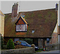
6
Saffrons House, Weavers Lane
Lying at right angles from the road and dating from the early 19th century. The field once surrounding it was known as Saffron Croft in Alfriston's 1842 tithe map.
Image: © Simon Carey
Taken: 27 Jan 2013
0.02 miles
8
Star Lane
Viewed from the junction with Kings Ride, Deans Road and Weavers Lane and looking towards the High Street which it joins between the Star Inn and Steamer Cottages. Alfriston Motors on the left operates from an old converted flint barn.
Image: © Simon Carey
Taken: 1 Jan 2013
0.03 miles
9
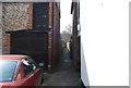
Rope Walk, Alfriston
A narrow walkway of the high St. Alfriston information http://www.alfriston.org/alfriston/index.htm
Image: © N Chadwick
Taken: 12 Apr 2010
0.03 miles
